1960s Maps of Bartow County, Georgia
Explore 8 historic maps of Bartow County from the 1960s. These maps offer a rare glimpse into what life looked like during the 1960s — showing old roads, neighborhoods, homes, and landmarks that have changed or disappeared over time.
Whether you're researching your family's past, planning a metal detecting trip, or studying how Bartow County's landscape evolved across the 1960s, these high-resolution maps are a powerful tool for exploring the history of this region.
- Focus on a specific era: All maps on this page are from the 1960s, giving you a focused view of this time period.
- See what’s changed: Compare century-old streets, trails, and buildings to today's modern landscape using overlays and satellite layers.
- Research with precision: Use these maps for genealogy, historical research, land use analysis, or educational projects.
- View, download, or print: Maps are fully viewable online in high resolution, and can be downloaded or printed for your own records.
Start exploring Bartow County's history through authentic maps from the 1960s. This is your window into the past.
Bartow County, GA maps
(8)- 1961 Map of Rome
 1961 Rome1961 Print · USGSNorthwest Georgia and neighboring Tennessee and Alabama are shown here at a moment of significant mid-century growth. Researchers can trace the rail networks of the Central of Georgia or locate landmarks within Chickamauga and Chattanooga Nat Military Park.
 - 1961 Map of Allatoona Dam, 1963 Print
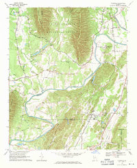
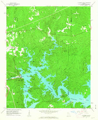 1961 Allatoona Dam1963 Print · USGSBartow and Cherokee counties are shown here just as the reservoir was becoming a regional recreation hub in the early sixties. Genealogists can trace old family burial grounds like Kay Cem and Goodson Cem, or locate rural landmarks like Stamp Creek Ch and Laffingal.4 unique versions available
 - 1963 Map of Rome
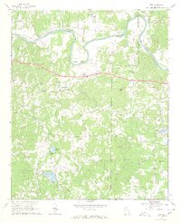
 1963 Rome1963 Print · USGSThe tri-state corner of Georgia, Alabama, and Tennessee is captured here during a period of massive reservoir expansion and post-war growth. Genealogists and historians can trace the rail corridors of the Southern Ry or locate landmarks like Fort Oglethorpe and Cloudland Canyon State Park.
 - 1968 Map of Allatoona Dam, 1969 Print
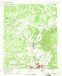
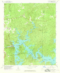 1968 Allatoona Dam1969 Print · USGSBartow County's landscape shows the full impact of the mid-century reservoir projects as recreation and nature preserves take hold in the late 1960s. Trace local family roots at Rowland Spring Cem or explore the site of the Allatoona Dam and its surrounding parklands.
 - 1968 Map of Wax, 1969 Print
 1968 Wax1969 Print · USGSFloyd and Bartow counties in the late sixties were defined by the winding Etowah River and several small rural congregations. Genealogists and historians can trace families through numerous local sites including Spring Hill Ch, Unity Cem, and the settlement at Wax.3 unique versions available
 - 1968 Map of Shannon, 1970 Print
 1968 Shannon1970 Print · USGSThe industrial and rural landscape of Floyd County in the late sixties is documented here before major suburban expansion. Researchers can find many family landmarks and civic centers like Morrison Campground, Rush Chapel, and the Model High Sch.4 unique versions available
 - 1968 Map of Rockmart North, 1970 Print
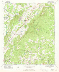
 1968 Rockmart North1970 Print · USGSNorthwest Georgia during the late sixties was a landscape of rail-dependent industrial towns and rural family farmsteads. Genealogists can trace ancestral sites like Shady Grove Ch, Rose Hill Cemetery, and the old quarries around Portland.2 unique versions available
 - 1968 Map of Plainville, 1971 Print
 1968 Plainville1971 Print · USGSThe Oostanaula River valley in the late sixties shows a traditional Georgia landscape of mountain ridges and riverside rail towns. Genealogists and historians can locate rural landmarks like New Hope Ch, the Georgia Cumberland Academy, and the Reeves Cem.2 unique versions available
End of results
Showing maps 1-8 of 8
Top cities of Bartow County
- Cartersville historical maps
- Adairsville historical maps
- Euharlee historical maps
- Emerson historical maps
- White historical maps
- Kingston historical maps
Frequently asked questions
- What are the different types of historical maps available for Bartow County?
- What is the oldest map of Bartow County?
- Where can I purchase historical maps of Bartow County for my home or office?
- Where can I download high-res historical maps of Bartow County?
- Are there historical topographic maps available for Bartow County?
- Is there historical aerial imagery available for Bartow County?
- Where are historical maps of Bartow County sourced from?