1970s Maps of Euharlee, Georgia
Explore 2 historic maps of Euharlee from the 1970s. These maps offer a rare glimpse into what life looked like during the 1970s — showing old roads, neighborhoods, homes, and landmarks that have changed or disappeared over time.
Whether you're researching your family's past, planning a metal detecting trip, or studying how Euharlee's landscape evolved across the 1970s, these high-resolution maps are a powerful tool for exploring the history of this region.
- Focus on a specific era: All maps on this page are from the 1970s, giving you a focused view of this time period.
- See what’s changed: Compare century-old streets, trails, and buildings to today's modern landscape using overlays and satellite layers.
- Research with precision: Use these maps for genealogy, historical research, land use analysis, or educational projects.
- View, download, or print: Maps are fully viewable online in high resolution, and can be downloaded or printed for your own records.
Start exploring Euharlee's history through authentic maps from the 1970s. This is your window into the past.
Euharlee, GA maps
(2)- 1972 Map of Taylorsville, 1974 Print
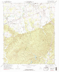 1972 Taylorsville1974 Print · USGSThe rural borderlands of Bartow and Polk counties are captured here in the early 1970s, showing a landscape defined by valley farming and rail junctions. You can trace local genealogy and land use through landmarks like Taylorsville Sch, Euharlee Ch, and the Claypit near the Seaboard tracks.2 unique versions available
 - 1972 Map of Kingston, 1974 Print
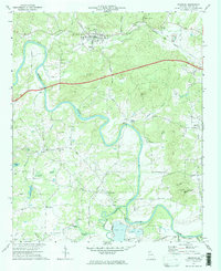 1972 Kingston1974 Print · USGSBartow County in the early seventies reveals a landscape deeply connected to its river valleys and rail history. Genealogists and local historians can trace legacy landmarks like Queens Chapel, the Covered Bridge over Euharlee Creek, and the old rail beds near Kingston.2 unique versions available
End of results
Showing maps 1-2 of 2
Top cities near Euharlee
- Rome historical maps
- Acworth historical maps
- Cartersville historical maps
- Dallas historical maps
- Adairsville historical maps
- Rockmart historical maps
See more
Frequently asked questions
- What are the different types of historical maps available for Euharlee?
- What is the oldest map of Euharlee?
- Where can I purchase historical maps of Euharlee for my home or office?
- Where can I download high-res historical maps of Euharlee?
- Are there historical topographic maps available for Euharlee?
- Is there historical aerial imagery available for Euharlee?
- Where are historical maps of Euharlee sourced from?