1970s Maps of White, Georgia
Explore 2 historic maps of White from the 1970s. These maps offer a rare glimpse into what life looked like during the 1970s — showing old roads, neighborhoods, homes, and landmarks that have changed or disappeared over time.
Whether you're researching your family's past, planning a metal detecting trip, or studying how White's landscape evolved across the 1970s, these high-resolution maps are a powerful tool for exploring the history of this region.
- Focus on a specific era: All maps on this page are from the 1970s, giving you a focused view of this time period.
- See what’s changed: Compare century-old streets, trails, and buildings to today's modern landscape using overlays and satellite layers.
- Research with precision: Use these maps for genealogy, historical research, land use analysis, or educational projects.
- View, download, or print: Maps are fully viewable online in high resolution, and can be downloaded or printed for your own records.
Start exploring White's history through authentic maps from the 1970s. This is your window into the past.
White, GA maps
(2)- 1972 Map of White West, 1974 Print
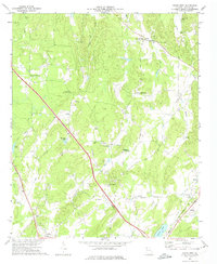 1972 White West1974 Print · USGSBartow County's rural crossroads and family homesteads are preserved here in the early 1970s. Researchers can locate community landmarks such as Towe Chapel, the Dora Harris Home Grave, and the rail stop at Aubrey.2 unique versions available
 - 1972 Map of White East, 1975 Print
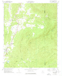 1972 White East1975 Print · USGSBartow and Cherokee counties are shown here in the early seventies, where the Louisville and Nashville rail line threads through a valley of rural congregations. Researchers can trace family roots at Fairview Ch and Millers Chapel or locate old industrial sites like the Quarry.2 unique versions available
End of results
Showing maps 1-2 of 2
Top cities near White
- Kennesaw historical maps
- Woodstock historical maps
- Canton historical maps
- Acworth historical maps
- Cartersville historical maps
- Calhoun historical maps
See more
Frequently asked questions
- What are the different types of historical maps available for White?
- What is the oldest map of White?
- Where can I purchase historical maps of White for my home or office?
- Where can I download high-res historical maps of White?
- Are there historical topographic maps available for White?
- Is there historical aerial imagery available for White?
- Where are historical maps of White sourced from?