1990s Maps of White, Georgia
Explore 1 historic maps of White from the 1990s. These maps offer a rare glimpse into what life looked like during the 1990s — showing old roads, neighborhoods, homes, and landmarks that have changed or disappeared over time.
Whether you're researching your family's past, planning a metal detecting trip, or studying how White's landscape evolved across the 1990s, these high-resolution maps are a powerful tool for exploring the history of this region.
- Focus on a specific era: All maps on this page are from the 1990s, giving you a focused view of this time period.
- See what’s changed: Compare century-old streets, trails, and buildings to today's modern landscape using overlays and satellite layers.
- Research with precision: Use these maps for genealogy, historical research, land use analysis, or educational projects.
- View, download, or print: Maps are fully viewable online in high resolution, and can be downloaded or printed for your own records.
Start exploring White's history through authentic maps from the 1990s. This is your window into the past.
White, GA maps
(1)- 1997 Map of White East, 1999 Print
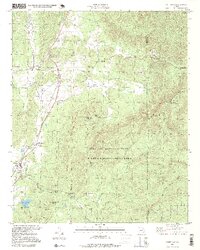 1997 White East1999 Print · USGSBartow and Cherokee counties are shown in the late nineties, where the high ridges of the Pine Log Mountain range meet rural Georgia communities. Genealogists and local historians can trace family locations near Millers Chapel, the Hickory Log Vocational Sch, and the rail stops at Rydal.
End of results
Showing maps 1-1 of 1
Top cities near White
- Kennesaw historical maps
- Woodstock historical maps
- Canton historical maps
- Acworth historical maps
- Cartersville historical maps
- Calhoun historical maps
See more
Frequently asked questions
- What are the different types of historical maps available for White?
- What is the oldest map of White?
- Where can I purchase historical maps of White for my home or office?
- Where can I download high-res historical maps of White?
- Are there historical topographic maps available for White?
- Is there historical aerial imagery available for White?
- Where are historical maps of White sourced from?