1970s Maps of Bowens Mill, Georgia
Explore 2 historic maps of Bowens Mill from the 1970s. These maps offer a rare glimpse into what life looked like during the 1970s — showing old roads, neighborhoods, homes, and landmarks that have changed or disappeared over time.
Whether you're researching your family's past, planning a metal detecting trip, or studying how Bowens Mill's landscape evolved across the 1970s, these high-resolution maps are a powerful tool for exploring the history of this region.
- Focus on a specific era: All maps on this page are from the 1970s, giving you a focused view of this time period.
- See what’s changed: Compare century-old streets, trails, and buildings to today's modern landscape using overlays and satellite layers.
- Research with precision: Use these maps for genealogy, historical research, land use analysis, or educational projects.
- View, download, or print: Maps are fully viewable online in high resolution, and can be downloaded or printed for your own records.
Start exploring Bowens Mill's history through authentic maps from the 1970s. This is your window into the past.
Bowens Mill, GA maps
(2)- 1972 Map of Queensland, 1988 Print
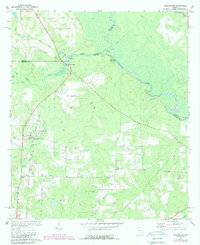 1972 Queensland1988 Print · USGSBen Hill County and the Ocmulgee River bottomlands are captured here in the early 1970s. Local researchers can trace family sites at Dixon Cem, locate the State Fish Hatchery, or follow the Old Railroad Grade through Queensland.
 - 1977 Map of Queensland
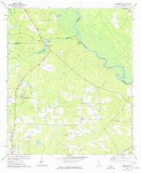 1977 Queensland1977 Print · USGSSettled along the Ocmulgee River in the late 1970s, this Ben Hill County landscape features a mix of river-based industry and rural community life. Researchers can trace family history at Evergreen Ch or study former transit lines along the OLD RAILROAD GRADE.
End of results
Showing maps 1-2 of 2
Top cities near Bowens Mill
Frequently asked questions
- What are the different types of historical maps available for Bowens Mill?
- What is the oldest map of Bowens Mill?
- Where can I purchase historical maps of Bowens Mill for my home or office?
- Where can I download high-res historical maps of Bowens Mill?
- Are there historical topographic maps available for Bowens Mill?
- Is there historical aerial imagery available for Bowens Mill?
- Where are historical maps of Bowens Mill sourced from?