1970s Maps of Nashville, Georgia
Explore 3 historic maps of Nashville from the 1970s. These maps offer a rare glimpse into what life looked like during the 1970s — showing old roads, neighborhoods, homes, and landmarks that have changed or disappeared over time.
Whether you're researching your family's past, planning a metal detecting trip, or studying how Nashville's landscape evolved across the 1970s, these high-resolution maps are a powerful tool for exploring the history of this region.
- Focus on a specific era: All maps on this page are from the 1970s, giving you a focused view of this time period.
- See what’s changed: Compare century-old streets, trails, and buildings to today's modern landscape using overlays and satellite layers.
- Research with precision: Use these maps for genealogy, historical research, land use analysis, or educational projects.
- View, download, or print: Maps are fully viewable online in high resolution, and can be downloaded or printed for your own records.
Start exploring Nashville's history through authentic maps from the 1970s. This is your window into the past.
Nashville, GA maps
(3)- 1973 Map of Nashville West, 1975 Print
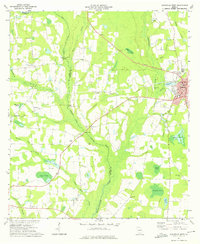 1973 Nashville West1975 Print · USGSBerrien and Cook counties appear in the early seventies, defined by the winding swamp systems of the New and Withlacoochee rivers. Researchers can locate the Old Railroad Grade and historic churches like Beulah Ch and Community Ch.
 - 1978 Map of Nashville East
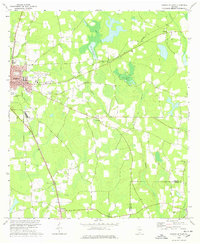 1978 Nashville East1978 Print · USGSNashville and the surrounding Berrien County countryside are captured here in the late 1970s as agricultural life and modern infrastructure intersected. Researchers can trace family sites at Gaskins Cem and Irene Ch or locate the old Central of Georgia rail corridor.
 - 1979 Map of Moultrie, 1980 Print
 1979 Moultrie1980 Print · USGSSouth Georgia’s agricultural heartland is documented here in the late 1970s, showcasing the intricate rail and river networks of Colquitt and Tift Counties. Researchers can trace historic settlements along the Georgia Northern railroad or locate landmarks like Spence Air Force Auxiliary Field and Banks Lake.2 unique versions available
End of results
Showing maps 1-3 of 3
Top cities near Nashville
- Tifton historical maps
- Adel historical maps
- Lakeland historical maps
- Hahira historical maps
- Sparks historical maps
- Willacoochee historical maps
See more
Frequently asked questions
- What are the different types of historical maps available for Nashville?
- What is the oldest map of Nashville?
- Where can I purchase historical maps of Nashville for my home or office?
- Where can I download high-res historical maps of Nashville?
- Are there historical topographic maps available for Nashville?
- Is there historical aerial imagery available for Nashville?
- Where are historical maps of Nashville sourced from?