1900s (20th Century) Maps of Stadium Walk, Statesboro
Explore 10 historic maps of Stadium Walk from the 1900s (20th Century). These maps offer a rare glimpse into what life looked like during the 1900s — showing old roads, neighborhoods, homes, and landmarks that have changed or disappeared over time.
Whether you're researching your family's past, planning a metal detecting trip, or studying how Stadium Walk's landscape evolved across the 1900s, these high-resolution maps are a powerful tool for exploring the history of this region.
- Focus on a specific era: All maps on this page are from the 1900s, giving you a focused view of this time period.
- See what’s changed: Compare century-old streets, trails, and buildings to today's modern landscape using overlays and satellite layers.
- Research with precision: Use these maps for genealogy, historical research, land use analysis, or educational projects.
- View, download, or print: Maps are fully viewable online in high resolution, and can be downloaded or printed for your own records.
Start exploring Stadium Walk's history through authentic maps from the 1900s. This is your window into the past.
Stadium Walk, Statesboro maps
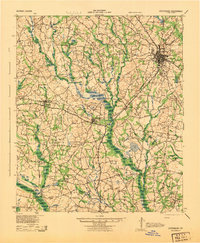
(10)- 1920 Map of Statesboro
 1920 Statesboro1920 Print · USGSSoutheast Georgia was a bustling junction of regional railways just after the First World War. Researchers can trace family roots and land ownership across a network of rural schools like Smith Allen Deaf School, small settlements like Adabelle, and the prominent Central of Georgia Railway.4 unique versions available
 - 1943 Map of Statesboro
 1943 Statesboro1943 Print · USGSStatesboro and its rural Georgia surroundings appear in wartime detail, showing the busy Central of Georgia rail lines and early road networks. Genealogists can trace family connections to many local landmarks like Smith Allen Deal Sch and Langston Chapel.
 - 1947 Map of Savannah
 1947 Savannah1947 Print · USGSCoastal Georgia and South Carolina are captured here in the mid-forties, showing the rail-and-river networks of the Lowcountry. Genealogists and researchers can trace old crossroads and river towns from Statesboro to Beaufort, alongside military sites like Camp Stewart and Parris Island.
 - 1948 Map of Savannah
 1948 Savannah1948 Print · USGSThe Georgia and South Carolina Lowcountry comes alive in this post-war survey of the coast and its river-fed hinterlands. Genealogists and historians can trace rail lines like the Central of Georgia RR and find established settlements such as Isle of Hope and Sylvania.
 - 1957 Map of Savannah, 1967 Print
 1957 Savannah1967 Print · USGSThe Lowcountry and Georgia coastal plain are shown here in the late fifties, prior to modern expansion. Researchers can trace the rail-and-river economy through the Central of Georgia lines and the Ogeechee River wetlands.4 unique versions available
 - 1960 Map of Savannah
 1960 Savannah1960 Print · USGSCoastal Georgia and the South Carolina Lowcountry are captured in the late fifties, showcasing the intricate web of islands and tidal rivers before modern expansion. Researchers can trace the rail lines of the Atlantic Coast Line or locate sites like Parris Island, Beaufort, and the Tybee Lighthouse.
 - 1961 Map of Savannah
 1961 Savannah1961 Print · USGSThe Georgia and South Carolina Lowcountry comes alive in this mid-century survey of coastal marshes, barrier islands, and river networks. Genealogists and historians can trace the paths of the Seaboard Air Line RR, locate family sites near Isle of Hope, or study the grounds of Fort Stewart Military Reservation.2 unique versions available
 - 1978 Map of Statesboro
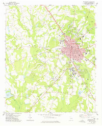 1978 Statesboro1978 Print · USGSStatesboro and the surrounding Bulloch County countryside appear in the late seventies as a bustling educational and agricultural center. Local researchers can trace family landmarks like Rigdon Cem, the small community of Jimps, and the Central of Georgia rail line.
 - 1981 Map of Savannah, 1982 Print
 1981 Savannah1982 Print · USGSCoastal Georgia and the South Carolina borderlands are captured here in the early eighties, showing the region's complex network of riverine islands and military installations. Researchers can trace the rail lines of the Central of Georgia and explore sites like Fort Stewart Military Reservation and Garden City.
 - 1993 Map of Statesboro, 1998 Print
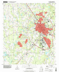 1993 Statesboro1998 Print · USGSStatesboro in the early nineties is a thriving center of education and commerce in Bulloch County. Trace the development of Georgia Southern College and find landmarks like Eastside Cem, Bird Pond, and the County Corr Inst.
End of results
Showing maps 1-10 of 10
Top cities near Stadium Walk
- Statesboro historical maps
- Brooklet historical maps
- Portal historical maps
- Pulaski historical maps
- Register historical maps
Frequently asked questions
- What are the different types of historical maps available for Stadium Walk?
- What is the oldest map of Stadium Walk?
- Where can I purchase historical maps of Stadium Walk for my home or office?
- Where can I download high-res historical maps of Stadium Walk?
- Are there historical topographic maps available for Stadium Walk?
- Is there historical aerial imagery available for Stadium Walk?
- Where are historical maps of Stadium Walk sourced from?