1900s (20th Century) Maps of Point Peter Landing, Georgia
Explore 11 historic maps of Point Peter Landing from the 1900s (20th Century). These maps offer a rare glimpse into what life looked like during the 1900s — showing old roads, neighborhoods, homes, and landmarks that have changed or disappeared over time.
Whether you're researching your family's past, planning a metal detecting trip, or studying how Point Peter Landing's landscape evolved across the 1900s, these high-resolution maps are a powerful tool for exploring the history of this region.
- Focus on a specific era: All maps on this page are from the 1900s, giving you a focused view of this time period.
- See what’s changed: Compare century-old streets, trails, and buildings to today's modern landscape using overlays and satellite layers.
- Research with precision: Use these maps for genealogy, historical research, land use analysis, or educational projects.
- View, download, or print: Maps are fully viewable online in high resolution, and can be downloaded or printed for your own records.
Start exploring Point Peter Landing's history through authentic maps from the 1900s. This is your window into the past.
Point Peter Landing, GA maps
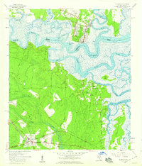
(11)- 1918 Map of St Marys
 1918 St Marys1918 Print · USGSCoastal Nassau County and the Georgia border are seen here just after the Great War, during a period of peak railroad expansion. Trace family roots and old landings at St Marys, Wild's Ferry, and the Evergreen School house.
 - 1919 Map of St Marys
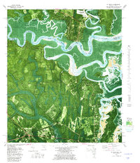
 1919 St Marys1919 Print · USGSThe Georgia-Florida borderlands near the coast were a patchwork of tidal marshes and rail towns just after the Great War. You can trace early river landings and rural schools like Evergreen School, Wilds Ferry, and the Seaboard Air Line rail stops.5 unique versions available
 - 1948 Map of Jacksonville
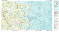
 1948 Jacksonville1948 Print · USGSNortheast Florida and Southeast Georgia's coastal waterways and railroad towns are captured here in the years following the war. Genealogists can trace family connections through river towns like St Marys or identify long-standing military landmarks like Jacksonville NAS.
 - 1957 Map of Jacksonville, 1967 Print
 1957 Jacksonville1967 Print · USGSCoastal Florida and Georgia meet in the late fifties, showcasing a landscape of naval aviation, deep-water terminals, and barrier island communities. Researchers can trace the mid-century footprints of NAS Jacksonville, find small communities like Franklintown, and locate the historic Fort Clinch State Park.3 unique versions available
 - 1958 Map of St. Marys, 1959 Print
 1958 St. Marys1959 Print · USGSThe Georgia-Florida borderlands come to life in this late fifties portrait of the tidal rivers and wetlands surrounding St Marys. Genealogists and historians can trace family roots through landmarks like Bryant Academy, Oak Grove Cem, and the tracks of the Seaboard Air Line.3 unique versions available
 - 1959 Map of Jacksonville
 1959 Jacksonville1959 Print · USGSNortheast Florida and Southeast Georgia are seen here in the late fifties, dominated by the maritime activity of the St Johns River and the Atlantic coast. Researchers can trace the mid-century layout of Jacksonville and identify sprawling military sites like Camp Blanding Military Reservation and Kings Bay Ammunition Terminal.
 - 1960 Map of Jacksonville
 1960 Jacksonville1960 Print · USGSCoastal Florida and Georgia meet in this mid-century portrait of a region shaped by naval power and the winding St Johns River. Researchers can trace the development of military sites like Cecil Field or locate historic rural landmarks such as Jerusalem Ch and Kings Ferry.
 - 1979 Map of St. Marys, 1980 Print
 1979 St. Marys1980 Print · USGSThe Georgia-Florida border comes alive in the late seventies as the tidal marshlands meet the growing grid of St. Marys. Researchers can trace old family settlements and local landmarks like Oak Grove Cem, Chester, and the Seaboard Coast Line.2 unique versions available
 - 1981 Map of Fernandina Beach, 1982 Print
 1981 Fernandina Beach1982 Print · USGSThe coastal borderlands of Georgia and Florida are captured here in the early eighties, from the barrier islands to the rail towns of the interior. Genealogists and historians can trace family-named bluffs and sites like Franklintown, Dungeness Wharf, and St Marys Historical Park.3 unique versions available
 - 1988 Map of Jacksonville
 1988 Jacksonville1988 Print · USGSCoastal Florida and Georgia are captured here during the late eighties, documenting the rapid growth of the First Coast and its vital military installations. Researchers can trace the development of beach communities like Fernandina Beach and Atlantic Beach or locate family landmarks near Mickler Landing and Orange Park.
 - 1993 Map of St Marys, 1995 Print
 1993 St Marys1995 Print · USGSThe coastal borderlands of Georgia and Florida come alive in the mid-nineties, centered on the historic riverfront of St Marys. Genealogists and local historians can trace family sites like Oak Grove Cem, Green Pine Cem, and the rural settlement at Chester.2 unique versions available
End of results
Showing maps 1-11 of 11
Top cities near Point Peter Landing
- Jacksonville historical maps
- St. Marys historical maps
- Kingsland historical maps
- Fernandina Beach historical maps
- Kings Bay Base historical maps
- Woodbine historical maps
Frequently asked questions
- What are the different types of historical maps available for Point Peter Landing?
- What is the oldest map of Point Peter Landing?
- Where can I purchase historical maps of Point Peter Landing for my home or office?
- Where can I download high-res historical maps of Point Peter Landing?
- Are there historical topographic maps available for Point Peter Landing?
- Is there historical aerial imagery available for Point Peter Landing?
- Where are historical maps of Point Peter Landing sourced from?