1970s Maps of The Estates of Sanctuary Cove, Camden County
Explore 2 historic maps of The Estates of Sanctuary Cove from the 1970s. These maps offer a rare glimpse into what life looked like during the 1970s — showing old roads, neighborhoods, homes, and landmarks that have changed or disappeared over time.
Whether you're researching your family's past, planning a metal detecting trip, or studying how The Estates of Sanctuary Cove's landscape evolved across the 1970s, these high-resolution maps are a powerful tool for exploring the history of this region.
- Focus on a specific era: All maps on this page are from the 1970s, giving you a focused view of this time period.
- See what’s changed: Compare century-old streets, trails, and buildings to today's modern landscape using overlays and satellite layers.
- Research with precision: Use these maps for genealogy, historical research, land use analysis, or educational projects.
- View, download, or print: Maps are fully viewable online in high resolution, and can be downloaded or printed for your own records.
Start exploring The Estates of Sanctuary Cove's history through authentic maps from the 1970s. This is your window into the past.
The Estates of Sanctuary Cove, Camden County maps
(2)- 1978 Map of Brunswick
 1978 Brunswick1978 Print · USGSThe Georgia coast and its barrier islands are captured in the late 1970s, as I-95 and the rail lines shaped the growth of coastal towns. Genealogists and historians can trace family locations across the islands or locate sites near Fort Stewart, Darien, and Ludowici.2 unique versions available
 - 1979 Map of Dover Bluff, 1980 Print
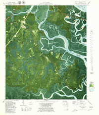 1979 Dover Bluff1980 Print · USGSThe Georgia coast near Dover Bluff comes into focus in the late 1970s, showing the intricate tidal marshlands of COLONELS ISLAND. Researchers can pinpoint the Old Spanish Mission Ruins and trace family roots through sites like Hull Cem and Ella Park Ch.2 unique versions available
End of results
Showing maps 1-2 of 2
Frequently asked questions
- What are the different types of historical maps available for The Estates of Sanctuary Cove?
- What is the oldest map of The Estates of Sanctuary Cove?
- Where can I purchase historical maps of The Estates of Sanctuary Cove for my home or office?
- Where can I download high-res historical maps of The Estates of Sanctuary Cove?
- Are there historical topographic maps available for The Estates of Sanctuary Cove?
- Is there historical aerial imagery available for The Estates of Sanctuary Cove?
- Where are historical maps of The Estates of Sanctuary Cove sourced from?