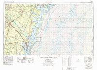
1978 Map of Brunswick
USGS Topo · Published 1978About this map
The Georgia coastline and the vast Altamaha river basin dominate this mid-to-late 1970s topographic study, illustrating the complex intersection of military reservations, protected wildlife sanctuaries, and coastal settlements. The inland landscape is defined by the Fort Stewart Military Reservation and the swampy lowlands of the Canoochee River and Altamaha River. Along the Atlantic, the map details a succession of barrier islands, including the Blackbeard Island National Wildlife Refuge and Jekyll Island State Park, alongside historic sites like Fort Frederica and Fort McAllister. The transportation network reveals the importance of both the Seaboard Coast Line and Southern Railway in connecting regional hubs like Jesup and Brunswick to the coastal ports. Deep in the interior, the transition from managed timberlands and swamps like Buffalo Swamp to the expanding suburbs near Hinesville reflects the shifting land use of the era.
Find a feature on this map
107 named features on this map. Tap any name to fly to it.
Don’t see what you’re looking for? This feature index may not catch every label — zoom into the map to look around manually.
Map Details
Editions of this 1978 Brunswick Map
2 editions found
Other maps of this area

1917 · Nahunta
USGS Topo · 1:62,500

1917 · Boulogne
USGS Topo · 1:62,500

1918 · Cumberland Island
USGS Topo · 1:62,500

1918 · Jesup
USGS Topo · 1:62,500

1918 · Folkston
USGS Topo · 1:62,500

1918 · Hortense
USGS Topo · 1:62,500

1918 · Hinesville
USGS Topo · 1:62,500

1918 · Everett City
USGS Topo · 1:62,500

1918 · Nahunta
USGS Topo · 1:62,500

1918 · Bladen
USGS Topo · 1:62,500