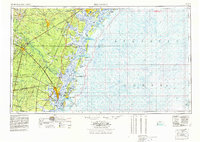
1978 Map of Brunswick
USGS Topo · Published 1978About this map
The Altamaha River and its intricate network of coastal sounds anchor this survey of Southeast Georgia's low country. This era finds the region defined by expansive federal and state holdings, from the massive Fort Stewart Military Reservation inland to the protected barrier islands of Blackbeard Island NWR and Wolf Island National Wildlife Refuge. The map captures a transition between the heavy industrial rail corridors of the Seaboard Coast Line and Southern railroads and the rising prominence of recreational and historical preserves like Jekyll Island State Park and Fort Frederica National Monument. To the north, Hunter Army Airfield sits near the marshlands of Skidaway Island State Park, while the port operations at Brunswick Harbor serve as a vital commercial hub for the surrounding timber and swamp lands.
Find a feature on this map
130 named features on this map. Tap any name to fly to it.
Don’t see what you’re looking for? This feature index may not catch every label — zoom into the map to look around manually.
Map Details
Editions of this 1978 Brunswick Map
2 editions found
Other maps of this area

1917 · Nahunta
USGS Topo · 1:62,500

1917 · Boulogne
USGS Topo · 1:62,500

1918 · Cumberland Island
USGS Topo · 1:62,500

1918 · Jesup
USGS Topo · 1:62,500

1918 · Folkston
USGS Topo · 1:62,500

1918 · Hortense
USGS Topo · 1:62,500

1918 · Hinesville
USGS Topo · 1:62,500

1918 · Everett City
USGS Topo · 1:62,500

1918 · Nahunta
USGS Topo · 1:62,500

1918 · Bladen
USGS Topo · 1:62,500