1970s Maps of Harrisons Mill, Georgia
Explore 1 historic maps of Harrisons Mill from the 1970s. These maps offer a rare glimpse into what life looked like during the 1970s — showing old roads, neighborhoods, homes, and landmarks that have changed or disappeared over time.
Whether you're researching your family's past, planning a metal detecting trip, or studying how Harrisons Mill's landscape evolved across the 1970s, these high-resolution maps are a powerful tool for exploring the history of this region.
- Focus on a specific era: All maps on this page are from the 1970s, giving you a focused view of this time period.
- See what’s changed: Compare century-old streets, trails, and buildings to today's modern landscape using overlays and satellite layers.
- Research with precision: Use these maps for genealogy, historical research, land use analysis, or educational projects.
- View, download, or print: Maps are fully viewable online in high resolution, and can be downloaded or printed for your own records.
Start exploring Harrisons Mill's history through authentic maps from the 1970s. This is your window into the past.
Harrisons Mill, GA maps
(1)- 1973 Map of Zetto, 1975 Print
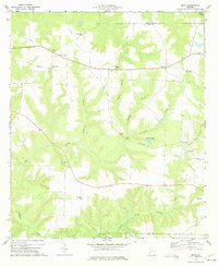 1973 Zetto1975 Print · USGSClay County and its neighbors in the early seventies remain a landscape of rural congregations and small agricultural hubs. Genealogists and local historians can trace the exact locations of many country landmarks, from the Clay Lookout Tower to Wesley Chapel and Harrisons Mill.
End of results
Showing maps 1-1 of 1
Top cities near Harrisons Mill
- Blakely historical maps
- Cuthbert historical maps
- Arlington historical maps
- Edison historical maps
- Fort Gaines historical maps
- Coleman historical maps
See more
Frequently asked questions
- What are the different types of historical maps available for Harrisons Mill?
- What is the oldest map of Harrisons Mill?
- Where can I purchase historical maps of Harrisons Mill for my home or office?
- Where can I download high-res historical maps of Harrisons Mill?
- Are there historical topographic maps available for Harrisons Mill?
- Is there historical aerial imagery available for Harrisons Mill?
- Where are historical maps of Harrisons Mill sourced from?