Old Maps of Shiloh Valley, Cobb County for Metal Detecting
Plan your next treasure hunt with 22 historic maps of Shiloh Valley. Find old homesites, ghost towns, trails, and gathering spots that may be lost to time — perfect for identifying promising metal detecting locations.
- Locate forgotten sites: Uncover places like long-lost settlements, abandoned rail lines, or gathering spots.
- Plan better hunts: Use map overlays combined with LiDAR or satellite views to narrow in on historically rich areas.
- Made for detectorists: Thousands of hobbyists use these maps to discover relics, coins, and hidden history.
Use these historic maps to boost your research and find new opportunities beneath the surface of Shiloh Valley.
Shiloh Valley, Cobb County maps
(22)- 1890 Map of Cartersville
 1890 Cartersville1890 Print · USGSCovers Shiloh Valley, including Marietta, Kennesaw, and other nearby areas
 - 1891 Map of Marietta
 1891 Marietta1891 Print · USGSCovers Shiloh Valley, including Atlanta, South Fulton, and other nearby areas
 - 1891 Map of Cartersville
 1891 Cartersville1891 Print · USGSCovers Shiloh Valley, including Marietta, Kennesaw, and other nearby areas
 - 1895 Map of Marietta
 1895 Marietta1895 Print · USGSCovers Shiloh Valley, including Atlanta, South Fulton, and other nearby areas
 - 1896 Map of Cartersville
 1896 Cartersville1896 Print · USGSCovers Shiloh Valley, including Marietta, Kennesaw, and other nearby areas4 unique versions available
 - 1897 Map of Marietta
 1897 Marietta1897 Print · USGSCovers Shiloh Valley, including Atlanta, South Fulton, and other nearby areas
 - 1901 Map of Marietta
 1901 Marietta1901 Print · USGSCovers Shiloh Valley, including Atlanta, South Fulton, and other nearby areas4 unique versions available
 - 1907 Map of Acworth, 1954 Print
 1907 Acworth1954 Print · USGSCovers Shiloh Valley, including Marietta, Kennesaw, and other nearby areas
 - 1909 Map of Acworth
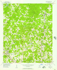
 1909 Acworth1909 Print · USGSCovers Shiloh Valley, including Marietta, Kennesaw, and other nearby areas
 - 1953 Map of Atlanta, 1965 Print
 1953 Atlanta1965 Print · USGSCovers Shiloh Valley, including Atlanta, Sandy Springs, and other nearby areas2 unique versions available
 - 1954 Map of Marietta, 1957 Print
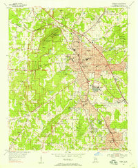 1954 Marietta1957 Print · USGSCovers Shiloh Valley, including Marietta, Smyrna, and other nearby areas6 unique versions available
 - 1955 Map of Rome
 1955 Rome1955 Print · USGSCovers Shiloh Valley, including Chattanooga, Sandy Springs, and other nearby areas
 - 1956 Map of Kennesaw, 1957 Print
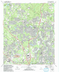
 1956 Kennesaw1957 Print · USGSCovers Shiloh Valley, including Marietta, Kennesaw, and other nearby areas5 unique versions available
 - 1957 Map of Atlanta
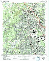
 1957 Atlanta1957 Print · USGSCovers Shiloh Valley, including Atlanta, Sandy Springs, and other nearby areas
 - 1958 Map of Atlanta
 1958 Atlanta1958 Print · USGSCovers Shiloh Valley, including Atlanta, Sandy Springs, and other nearby areas
 - 1958 Map of Rome, 1966 Print
 1958 Rome1966 Print · USGSCovers Shiloh Valley, including Chattanooga, Sandy Springs, and other nearby areas3 unique versions available
 - 1961 Map of Rome
 1961 Rome1961 Print · USGSCovers Shiloh Valley, including Chattanooga, Sandy Springs, and other nearby areas
 - 1963 Map of Rome
 1963 Rome1963 Print · USGSCovers Shiloh Valley, including Chattanooga, Sandy Springs, and other nearby areas
 - 1981 Map of Cartersville, 1982 Print
 1981 Cartersville1982 Print · USGSCovers Shiloh Valley, including Sandy Springs, Roswell, and other nearby areas2 unique versions available
 - 1981 Map of Atlanta, 1982 Print
 1981 Atlanta1982 Print · USGSCovers Shiloh Valley, including Atlanta, Sandy Springs, and other nearby areas
 - 1992 Map of Marietta
 1992 Marietta1992 Print · USGSCovers Shiloh Valley, including Marietta, Smyrna, and other nearby areas2 unique versions available
 - 1992 Map of Kennesaw, 1993 Print
 1992 Kennesaw1993 Print · USGSCovers Shiloh Valley, including Marietta, Kennesaw, and other nearby areas2 unique versions available
End of results
Showing maps 1-22 of 22
Frequently asked questions
- What are the different types of historical maps available for Shiloh Valley?
- What is the oldest map of Shiloh Valley?
- Where can I purchase historical maps of Shiloh Valley for my home or office?
- Where can I download high-res historical maps of Shiloh Valley?
- Are there historical topographic maps available for Shiloh Valley?
- Is there historical aerial imagery available for Shiloh Valley?
- Where are historical maps of Shiloh Valley sourced from?