1960s Maps of Wedgewood, Georgia
Explore 1 historic maps of Wedgewood from the 1960s. These maps offer a rare glimpse into what life looked like during the 1960s — showing old roads, neighborhoods, homes, and landmarks that have changed or disappeared over time.
Whether you're researching your family's past, planning a metal detecting trip, or studying how Wedgewood's landscape evolved across the 1960s, these high-resolution maps are a powerful tool for exploring the history of this region.
- Focus on a specific era: All maps on this page are from the 1960s, giving you a focused view of this time period.
- See what’s changed: Compare century-old streets, trails, and buildings to today's modern landscape using overlays and satellite layers.
- Research with precision: Use these maps for genealogy, historical research, land use analysis, or educational projects.
- View, download, or print: Maps are fully viewable online in high resolution, and can be downloaded or printed for your own records.
Start exploring Wedgewood's history through authentic maps from the 1960s. This is your window into the past.
Wedgewood, GA maps
(1)- 1965 Map of Newnan North, 1966 Print
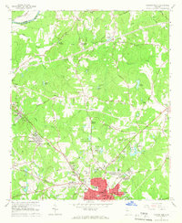 1965 Newnan North1966 Print · USGSIn the mid-sixties, the area north of Newnan was a mix of growing neighborhoods and long-standing rural outposts. Genealogists and historians can trace family roots through landmarks like Sewell Millpond, Jones Chapel Cem, and the industrial hamlet of Arneo Mills.3 unique versions available
End of results
Showing maps 1-1 of 1
Top cities near Wedgewood
- South Fulton historical maps
- Newnan historical maps
- Peachtree City historical maps
- Carrollton historical maps
- Union City historical maps
- Fairburn historical maps
See more
Frequently asked questions
- What are the different types of historical maps available for Wedgewood?
- What is the oldest map of Wedgewood?
- Where can I purchase historical maps of Wedgewood for my home or office?
- Where can I download high-res historical maps of Wedgewood?
- Are there historical topographic maps available for Wedgewood?
- Is there historical aerial imagery available for Wedgewood?
- Where are historical maps of Wedgewood sourced from?