1990s Maps of Dunn, Georgia
Explore 2 historic maps of Dunn from the 1990s. These maps offer a rare glimpse into what life looked like during the 1990s — showing old roads, neighborhoods, homes, and landmarks that have changed or disappeared over time.
Whether you're researching your family's past, planning a metal detecting trip, or studying how Dunn's landscape evolved across the 1990s, these high-resolution maps are a powerful tool for exploring the history of this region.
- Focus on a specific era: All maps on this page are from the 1990s, giving you a focused view of this time period.
- See what’s changed: Compare century-old streets, trails, and buildings to today's modern landscape using overlays and satellite layers.
- Research with precision: Use these maps for genealogy, historical research, land use analysis, or educational projects.
- View, download, or print: Maps are fully viewable online in high resolution, and can be downloaded or printed for your own records.
Start exploring Dunn's history through authentic maps from the 1990s. This is your window into the past.
Dunn, GA maps
(2)- 1992 Map of Cumming, 1993 Print
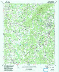 1992 Cumming1993 Print · USGSCumming and southern Forsyth County were on the verge of significant growth in the early nineties as the Atlanta suburbs expanded north. Researchers can trace family sites and local landmarks like Sawnee Mountain, Ducktown, and historic congregations at Daves Creek Ch and Shiloh Ch.
 - 1999 Map of Cumming, 2003 Print
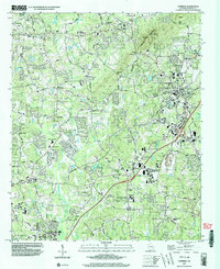 1999 Cumming2003 Print · USGSNorth Georgia’s suburban expansion meets the ridgeline of the Blue Ridge foothills in the final years of the millennium. Genealogists and local researchers can pinpoint family landmarks from Ducktown to Brandywine Community House, along with numerous historic congregations like Friendship Ch and Shiloh Ch.
End of results
Showing maps 1-2 of 2
Top cities near Dunn
- Roswell historical maps
- Johns Creek historical maps
- Alpharetta historical maps
- Milton historical maps
- Duluth historical maps
- Sugar Hill historical maps
See more
Frequently asked questions
- What are the different types of historical maps available for Dunn?
- What is the oldest map of Dunn?
- Where can I purchase historical maps of Dunn for my home or office?
- Where can I download high-res historical maps of Dunn?
- Are there historical topographic maps available for Dunn?
- Is there historical aerial imagery available for Dunn?
- Where are historical maps of Dunn sourced from?