1990s Maps of Misty Ridge, Sandy Springs
Explore 2 historic maps of Misty Ridge from the 1990s. These maps offer a rare glimpse into what life looked like during the 1990s — showing old roads, neighborhoods, homes, and landmarks that have changed or disappeared over time.
Whether you're researching your family's past, planning a metal detecting trip, or studying how Misty Ridge's landscape evolved across the 1990s, these high-resolution maps are a powerful tool for exploring the history of this region.
- Focus on a specific era: All maps on this page are from the 1990s, giving you a focused view of this time period.
- See what’s changed: Compare century-old streets, trails, and buildings to today's modern landscape using overlays and satellite layers.
- Research with precision: Use these maps for genealogy, historical research, land use analysis, or educational projects.
- View, download, or print: Maps are fully viewable online in high resolution, and can be downloaded or printed for your own records.
Start exploring Misty Ridge's history through authentic maps from the 1990s. This is your window into the past.
Misty Ridge, Sandy Springs maps
(2)- 1993 Map of Sandy Springs, 1995 Print
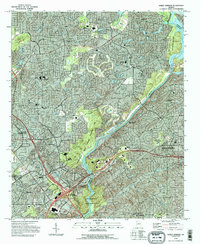 1993 Sandy Springs1995 Print · USGSSandy Springs and the northern Atlanta suburbs are shown here in the early nineties as modern infrastructure integrated with historic local landmarks. Researchers can trace the development of Marietta near Dobbins Air Force Base and locate community anchors like Mt Bethel Ch and Campground Cem.
 - 1997 Map of Sandy Springs, 1999 Print
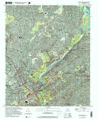 1997 Sandy Springs1999 Print · USGSThe northern Atlanta suburbs were undergoing significant expansion during the late nineties, as residential growth converged with the Chattahoochee River. Researchers can trace the development of Marietta and Sandy Springs through landmarks like Dobbins AFB and Cumberland Mall Shopping Center.
End of results
Showing maps 1-2 of 2
Frequently asked questions
- What are the different types of historical maps available for Misty Ridge?
- What is the oldest map of Misty Ridge?
- Where can I purchase historical maps of Misty Ridge for my home or office?
- Where can I download high-res historical maps of Misty Ridge?
- Are there historical topographic maps available for Misty Ridge?
- Is there historical aerial imagery available for Misty Ridge?
- Where are historical maps of Misty Ridge sourced from?