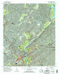
1993 Map of Sandy Springs
USGS Topo · Published 1995About this map
The Chattahoochee River carves a diagonal path through this suburban landscape during the early 1990s, defining the boundary between Cobb and Fulton counties. This survey illustrates the dense residential and commercial expansion in northern Georgia, anchored by the Sandy Springs settlement and the industrial and retail hubs of Marietta and Smyrna. The proximity of Dobbins Air Force Base and the Cumberland Mall Shopping Center highlights the rapid suburbanization of the era, while the Chattahoochee River National Recreation Area preserves a corridor of green space amidst the grid of emerging subdivisions.
Find a feature on this map
61 named features on this map. Tap any name to fly to it.
Don’t see what you’re looking for? This feature index may not catch every label — zoom into the map to look around manually.
Map Details
Editions of this 1993 Sandy Springs Map
This is the sole edition of this map. No revisions or reprints were ever made.
Other maps of this area

1888 · Atlanta
USGS Topo · 1:125,000

1890 · Suwanee
USGS Topo · 1:125,000

1890 · Cartersville
USGS Topo · 1:125,000

1890 · Atlanta
USGS Topo · 1:125,000

1891 · Marietta
USGS Topo · 1:125,000

1891 · Cartersville
USGS Topo · 1:125,000

1892 · Atlanta
USGS Topo · 1:125,000

1894 · Suwanee
USGS Topo · 1:125,000

1895 · Atlanta
USGS Topo · 1:125,000

1895 · Marietta
USGS Topo · 1:125,000