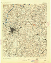
1892 Map of Atlanta
USGS Topo · Published 1892About this map
Atlanta emerges as a dense railroad hub in the late 1880s, anchored by the Georgia Railroad and the Western and Atlantic Railroad radiating from the city center. This survey captures the region just as suburban precursors like Edgewood and Decatur were beginning to coalesce around the established rail lines. North of the city, the Chattahoochee River is dotted with essential river crossings including Jetts Ferry and Paces Ferry, reflecting a landscape where water travel and milling at sites like Howells Mills remained vital to the local economy.
Find a feature on this map
123 named features on this map. Tap any name to fly to it.
Don’t see what you’re looking for? This feature index may not catch every label — zoom into the map to look around manually.
Map Details
Editions of this 1892 Atlanta Map
This is the sole edition of this map. No revisions or reprints were ever made.
Historical Maps of Atlanta Through Time
8 maps found