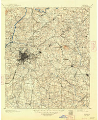
1890 Map of Atlanta
USGS Topo · Published 1890About this map
The Chattahoochee River corridor is defined by a series of crossings and industrial sites such as Oakley Mill, Heard's Ferry, and Defoors Ferry, documenting the transportation network before the proliferation of modern bridges. The city center is a dense hub of converging rail lines, including the Georgia Railroad and the Atlanta and Florida Railroad, which fueled the rapid post-war expansion into nearby suburbs like Edgewood and Buckhead. To the east, the prominent relief of Stone Mountain towers over a landscape of smaller rural communities and farm-side stops such as Tricum and Brownings Store. Educational and religious foundations appear through sites like Clarks University and the Cornell church, while the peripheral regions are dotted with family-named landmarks like Jetts Store and Butlers Bridge, providing specific points of interest for genealogists tracing ancestral land holdings in Fulton and De Kalb counties.
Find a feature on this map
142 named features on this map. Tap any name to fly to it.
Don’t see what you’re looking for? This feature index may not catch every label — zoom into the map to look around manually.
Map Details
Editions of this 1890 Atlanta Map
This is the sole edition of this map. No revisions or reprints were ever made.
Historical Maps of Atlanta Through Time
8 maps found