
Loading...
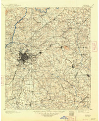
Loading map...1888 Map of Atlanta
USGS Topo · Published 1955About this map
Chattahoochee River crossings and a dense lattice of early railroads define the Georgia landscape in the late nineteenth century. The urban core of Atlanta is surrounded by a periphery of smaller settlements and junctions such as Decatur, East End, and Dunwoody. This era highlights a transition toward industrialization, visible through landmarks like the Exposition grounds and multiple milling operations including Oakley Mill and Wilson Mill.
Find a feature on this map
187 named features on this map. Tap any name to fly to it.
Don’t see what you’re looking for? This feature index may not catch every label — zoom into the map to look around manually.
Map Details
Date Portrayed1888
Date Published1955
PublisherU.S. Geological Survey
Map TypeTopographic
Scale1:125,000
Physical Dimensions17 x 20.8 inches
Editions of this 1888 Atlanta Map
This is the sole edition of this map. No revisions or reprints were ever made.
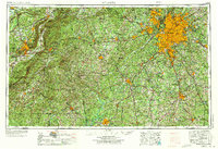
Historical Maps of Atlanta Through Time
8 maps found


Featured Locations
Source Details
SourceU.S. Geological Survey
CopyrightPublic Domain