1920s Maps of Boys Estate, Georgia
Explore 1 historic maps of Boys Estate from the 1920s. These maps offer a rare glimpse into what life looked like during the 1920s — showing old roads, neighborhoods, homes, and landmarks that have changed or disappeared over time.
Whether you're researching your family's past, planning a metal detecting trip, or studying how Boys Estate's landscape evolved across the 1920s, these high-resolution maps are a powerful tool for exploring the history of this region.
- Focus on a specific era: All maps on this page are from the 1920s, giving you a focused view of this time period.
- See what’s changed: Compare century-old streets, trails, and buildings to today's modern landscape using overlays and satellite layers.
- Research with precision: Use these maps for genealogy, historical research, land use analysis, or educational projects.
- View, download, or print: Maps are fully viewable online in high resolution, and can be downloaded or printed for your own records.
Start exploring Boys Estate's history through authentic maps from the 1920s. This is your window into the past.
Boys Estate, GA maps
(1)- 1921 Map of Darien, 1937 Print
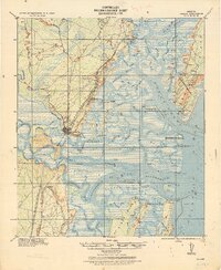 1921 Darien1937 Print · USGSThe Georgia coast near Darien is captured here in the years following the Great War, showing a landscape defined by rice milling and rail. Genealogists can locate family landmarks like Patterson and Meridian, or industrial sites such as the Butler Rice Mill Chimney.
End of results
Showing maps 1-1 of 1
Top cities near Boys Estate
- Brunswick historical maps
- Saint Simons historical maps
- Country Club Estates historical maps
- Dock Junction historical maps
- Darien historical maps
Frequently asked questions
- What are the different types of historical maps available for Boys Estate?
- What is the oldest map of Boys Estate?
- Where can I purchase historical maps of Boys Estate for my home or office?
- Where can I download high-res historical maps of Boys Estate?
- Are there historical topographic maps available for Boys Estate?
- Is there historical aerial imagery available for Boys Estate?
- Where are historical maps of Boys Estate sourced from?