1900s (20th Century) Maps of Drakes Landing, Glynn County
Explore 11 historic maps of Drakes Landing from the 1900s (20th Century). These maps offer a rare glimpse into what life looked like during the 1900s — showing old roads, neighborhoods, homes, and landmarks that have changed or disappeared over time.
Whether you're researching your family's past, planning a metal detecting trip, or studying how Drakes Landing's landscape evolved across the 1900s, these high-resolution maps are a powerful tool for exploring the history of this region.
- Focus on a specific era: All maps on this page are from the 1900s, giving you a focused view of this time period.
- See what’s changed: Compare century-old streets, trails, and buildings to today's modern landscape using overlays and satellite layers.
- Research with precision: Use these maps for genealogy, historical research, land use analysis, or educational projects.
- View, download, or print: Maps are fully viewable online in high resolution, and can be downloaded or printed for your own records.
Start exploring Drakes Landing's history through authentic maps from the 1900s. This is your window into the past.
Drakes Landing, Glynn County maps
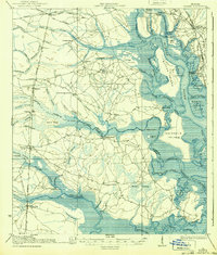
(11)- 1918 Map of Bladen
 1918 Bladen1918 Print · USGSThe Georgia coast at the end of the Great War reveals a landscape of tidal marshes and vital rail junctions. Genealogists can trace family roots through sites like Brockington School, Dover Bluff, and the junction at Bladen.2 unique versions available
 - 1939 Map of Bladen
 1939 Bladen1939 Print · USGSCoastal Glynn and Camden counties in the late 1930s reveal a landscape of intricate tidal marshes and emerging rail hubs. Genealogists and historians can trace the foundations of local life through the Waverly settlement, the Waverly Tramroad, and rural landmarks like the Magnolia School.2 unique versions available
 - 1946 Map of Brunswick, 1948 Print
 1946 Brunswick1948 Print · USGSCoastal Georgia in the mid-forties reveals a landscape defined by the Camp Stewart Military Reservation and the sprawling barrier islands. Genealogists and historians can trace the rail-and-river network through inland towns like Ludowici and Jesup, or locate coastal landmarks like the St Simon Light.
 - 1948 Map of Brunswick
 1948 Brunswick1948 Print · USGSCoastal Georgia in the late 1940s is defined here by its labyrinthine barrier islands and the massive footprint of Camp Stewart. Genealogists and historians can trace the rail-tied growth of Jesup and Hinesville or locate coastal landmarks like St Simon Light.
 - 1956 Map of Bladen, 1959 Print
 1956 Bladen1959 Print · USGSCoastal Glynn and Camden counties are captured here in the mid-1950s, a period defined by the intersections of the Atlantic Coast Line and the Seaboard Air Line. Researchers can locate family landmarks such as Higgenbottom Cem and rural centers like Brookman and New Zion Ch.
 - 1956 Map of Brunswick, 1968 Print
 1956 Brunswick1968 Print · USGSThe Georgia coast in the mid-twentieth century is a wild expanse of barrier islands and massive river deltas. You can trace the development of the maritime economy and military presence at Brunswick, or locate historic sites like Fort Frederica National Monument and Harris Neck National Wildlife Refuge.2 unique versions available
 - 1961 Map of Brunswick
 1961 Brunswick1961 Print · USGSThe Georgia coast at the start of the 1960s was a landscape of deep tidal marshes and growing military installations. Genealogists and historians can trace rail-linked towns like Limerick Station or explore coastal landmarks from Fort Frederica National Monument to Sapelo Island.
 - 1978 Map of Brunswick
 1978 Brunswick1978 Print · USGSThe Georgia coast and its barrier islands are captured in the late 1970s, as I-95 and the rail lines shaped the growth of coastal towns. Genealogists and historians can trace family locations across the islands or locate sites near Fort Stewart, Darien, and Ludowici.2 unique versions available
 - 1980 Map of Bladen
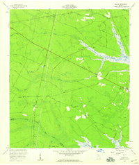
 1980 Bladen1980 Print · USGSThe coastal wetlands of Glynn and Camden Counties are captured here during the 1970s, showcasing a landscape of riverine trade and timber. Family historians can locate Magnolia Cemetery or trace the old paths of Shingle Mill Road and the Seaboard Coast Line.2 unique versions available
 - 1981 Map of Brunswick, 1982 Print
 1981 Brunswick1982 Print · USGSThe Georgia coast at the start of the eighties reveals a complex landscape of tidal estuaries, deep-water sounds, and growing island communities. Trace local history through the protected grounds of Fort Frederica National Monument and the old rail stops at Thalmann and Nahunta.3 unique versions available
 - 1993 Map of Bladen, 1995 Print
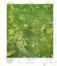
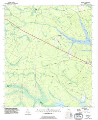 1993 Bladen1995 Print · USGSCoastal Georgia's riverine lowlands come into focus in the early nineties, showing a landscape of tidal swamps and rural junctions. Genealogists can trace family names at the Higginbotham Cemetery and Wright Cemetery, or locate community hubs like New Zion Church.
End of results
Showing maps 1-11 of 11
Frequently asked questions
- What are the different types of historical maps available for Drakes Landing?
- What is the oldest map of Drakes Landing?
- Where can I purchase historical maps of Drakes Landing for my home or office?
- Where can I download high-res historical maps of Drakes Landing?
- Are there historical topographic maps available for Drakes Landing?
- Is there historical aerial imagery available for Drakes Landing?
- Where are historical maps of Drakes Landing sourced from?