1980s Maps of Palmetto Point, Glynn County
Explore 2 historic maps of Palmetto Point from the 1980s. These maps offer a rare glimpse into what life looked like during the 1980s — showing old roads, neighborhoods, homes, and landmarks that have changed or disappeared over time.
Whether you're researching your family's past, planning a metal detecting trip, or studying how Palmetto Point's landscape evolved across the 1980s, these high-resolution maps are a powerful tool for exploring the history of this region.
- Focus on a specific era: All maps on this page are from the 1980s, giving you a focused view of this time period.
- See what’s changed: Compare century-old streets, trails, and buildings to today's modern landscape using overlays and satellite layers.
- Research with precision: Use these maps for genealogy, historical research, land use analysis, or educational projects.
- View, download, or print: Maps are fully viewable online in high resolution, and can be downloaded or printed for your own records.
Start exploring Palmetto Point's history through authentic maps from the 1980s. This is your window into the past.
Palmetto Point, Glynn County maps
(2)- 1980 Map of Bladen
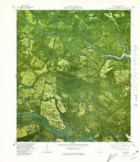 1980 Bladen1980 Print · USGSThe coastal wetlands of Glynn and Camden Counties are captured here during the 1970s, showcasing a landscape of riverine trade and timber. Family historians can locate Magnolia Cemetery or trace the old paths of Shingle Mill Road and the Seaboard Coast Line.2 unique versions available
 - 1981 Map of Brunswick, 1982 Print
 1981 Brunswick1982 Print · USGSThe Georgia coast at the start of the eighties reveals a complex landscape of tidal estuaries, deep-water sounds, and growing island communities. Trace local history through the protected grounds of Fort Frederica National Monument and the old rail stops at Thalmann and Nahunta.3 unique versions available
End of results
Showing maps 1-2 of 2
Frequently asked questions
- What are the different types of historical maps available for Palmetto Point?
- What is the oldest map of Palmetto Point?
- Where can I purchase historical maps of Palmetto Point for my home or office?
- Where can I download high-res historical maps of Palmetto Point?
- Are there historical topographic maps available for Palmetto Point?
- Is there historical aerial imagery available for Palmetto Point?
- Where are historical maps of Palmetto Point sourced from?