1950s Maps of Parade Rest, Georgia
Explore 2 historic maps of Parade Rest from the 1950s. These maps offer a rare glimpse into what life looked like during the 1950s — showing old roads, neighborhoods, homes, and landmarks that have changed or disappeared over time.
Whether you're researching your family's past, planning a metal detecting trip, or studying how Parade Rest's landscape evolved across the 1950s, these high-resolution maps are a powerful tool for exploring the history of this region.
- Focus on a specific era: All maps on this page are from the 1950s, giving you a focused view of this time period.
- See what’s changed: Compare century-old streets, trails, and buildings to today's modern landscape using overlays and satellite layers.
- Research with precision: Use these maps for genealogy, historical research, land use analysis, or educational projects.
- View, download, or print: Maps are fully viewable online in high resolution, and can be downloaded or printed for your own records.
Start exploring Parade Rest's history through authentic maps from the 1950s. This is your window into the past.
Parade Rest, GA maps
(2)- 1956 Map of Brunswick West, 1960 Print
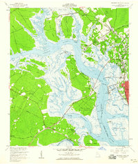 1956 Brunswick West1960 Print · USGSThe coastal marshlands and river junctions of Glynn County are captured here in the mid-1950s. Genealogists and historians can trace rail lines to Southern Junction, locate the Blythe Island Naval Reservation, and find rural landmarks like Emanuel Ch.2 unique versions available
 - 1956 Map of Brunswick, 1968 Print
 1956 Brunswick1968 Print · USGSThe Georgia coast in the mid-twentieth century is a wild expanse of barrier islands and massive river deltas. You can trace the development of the maritime economy and military presence at Brunswick, or locate historic sites like Fort Frederica National Monument and Harris Neck National Wildlife Refuge.2 unique versions available
End of results
Showing maps 1-2 of 2
Top cities near Parade Rest
- Brunswick historical maps
- Saint Simons historical maps
- Country Club Estates historical maps
- Dock Junction historical maps
- Darien historical maps
Frequently asked questions
- What are the different types of historical maps available for Parade Rest?
- What is the oldest map of Parade Rest?
- Where can I purchase historical maps of Parade Rest for my home or office?
- Where can I download high-res historical maps of Parade Rest?
- Are there historical topographic maps available for Parade Rest?
- Is there historical aerial imagery available for Parade Rest?
- Where are historical maps of Parade Rest sourced from?