1970s Maps of Gordon County, Georgia
Explore 7 historic maps of Gordon County from the 1970s. These maps offer a rare glimpse into what life looked like during the 1970s — showing old roads, neighborhoods, homes, and landmarks that have changed or disappeared over time.
Whether you're researching your family's past, planning a metal detecting trip, or studying how Gordon County's landscape evolved across the 1970s, these high-resolution maps are a powerful tool for exploring the history of this region.
- Focus on a specific era: All maps on this page are from the 1970s, giving you a focused view of this time period.
- See what’s changed: Compare century-old streets, trails, and buildings to today's modern landscape using overlays and satellite layers.
- Research with precision: Use these maps for genealogy, historical research, land use analysis, or educational projects.
- View, download, or print: Maps are fully viewable online in high resolution, and can be downloaded or printed for your own records.
Start exploring Gordon County's history through authentic maps from the 1970s. This is your window into the past.
Gordon County, GA maps
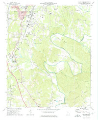
(7)- 1971 Map of Oakman, 1973 Print
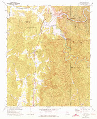 1971 Oakman1973 Print · USGSNorth Georgia’s mountain landscape is captured here during the 1970s as new reservoirs began to reshape the river valleys. Researchers can locate several rural churches and rail-side communities like Oakman, Hopewell Ch, and Sweden near the Louisville and Nashville line.2 unique versions available
 - 1972 Map of Calhoun South, 1974 Print
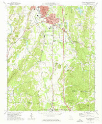 1972 Calhoun South1974 Print · USGSThe rural landscape between Calhoun and Adairsville is captured here in the early seventies as the interstate era began to reshape Northwest Georgia. Genealogists can locate family-named sites like McDaniels and Lily Pond, or trace rural congregations at Philadelphia Ch and Oothkalooga Ch.2 unique versions available
 - 1972 Map of Fairmount, 1974 Print
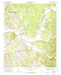
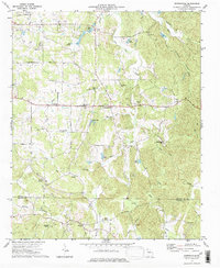
 1972 Fairmount1974 Print · USGSFairmount and the Salacoa Valley are shown in the early seventies as the railroad and rural highway networks defined life in North Georgia. Researchers can trace family sites at Shiloh Cem, the remote community of Ryo, and the quarries near Funkhouser.2 unique versions available
 - 1972 Map of Redbud, 1974 Print
 1972 Redbud1974 Print · USGSIn the early 1970s, this area of Gordon County featured a dense network of riverfront settlements and rural churches along the Coosawattee River. Genealogists can trace local landmarks like Redbud Sch, Crane Eater, and family-named points such as Hunts Corner.2 unique versions available
 - 1972 Map of Calhoun North, 1974 Print
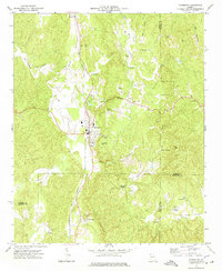
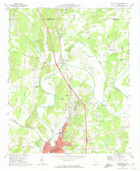 1972 Calhoun North1974 Print · USGSThe river-rich landscape of Gordon County is captured here in the early 1970s as agricultural lands and historic sites meet modern infrastructure. Genealogists and historians can trace family roots at the Resaca Confederate Cem, the New Echota Historical Site, and small settlements like Nance Springs.3 unique versions available
 - 1972 Map of Sonoraville, 1974 Print
 1972 Sonoraville1974 Print · USGSGordon County and Bartow County during the early 1970s reveal a landscape defined by traditional rural communities and deep-rooted family landmarks. Genealogists can trace local history through sites like Yarbroughs Mill, Sonoraville Sch, and Bethlehem Ch.2 unique versions available
 - 1972 Map of Dalton South, 1974 Print
 1972 Dalton South1974 Print · USGSWhitfield County in the early seventies shows the intersection of industrial growth and rural heritage south of Dalton. Genealogists and historians can trace family locations near Tilton, old landmarks like Keiths Mill, and numerous country churches such as River Bend Ch.2 unique versions available
End of results
Showing maps 1-7 of 7
Top cities of Gordon County
- Calhoun historical maps
- Fairmount historical maps
- Resaca historical maps
- Plainville historical maps
- Ranger historical maps
Frequently asked questions
- What are the different types of historical maps available for Gordon County?
- What is the oldest map of Gordon County?
- Where can I purchase historical maps of Gordon County for my home or office?
- Where can I download high-res historical maps of Gordon County?
- Are there historical topographic maps available for Gordon County?
- Is there historical aerial imagery available for Gordon County?
- Where are historical maps of Gordon County sourced from?