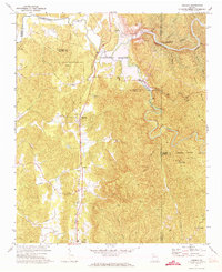
1971 Map of Oakman
USGS Topo · Published 1973About this map
Oakman and Ranger serve as the primary hubs of activity along the Louisville and Nashville rail corridor in this early 1970s survey. The landscape is defined by significant hydrologic engineering, featuring the massive Carters Dam and the sprawling Carters Lake, alongside the downstream Reregulation Reservoir. These man-made features dominate the northern section of the sheet, where the Coosawattee River is harnessed for power and flood control. Away from the water, a network of rural congregations such as Banks Chapel, Hopewell Ch, and New Hope Ch anchor the local communities. The terrain transitions from the river valleys to the heights of Blalock Mountain in the east, where the winding Talking Rock Creek carves a deep path through the hills. This map documents a period when modern infrastructure and traditional mountain settlements coexisted.
Find a feature on this map
49 named features on this map. Tap any name to fly to it.
Don’t see what you’re looking for? This feature index may not catch every label — zoom into the map to look around manually.
Map Details
Editions of this 1971 Oakman Map
2 editions found
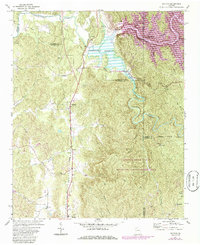
Other maps of this area

1886 · Dalton
USGS Topo · 1:125,000

1890 · Cartersville
USGS Topo · 1:125,000

1891 · Cartersville
USGS Topo · 1:125,000

1892 · Dalton
USGS Topo · 1:125,000

1896 · Cartersville
USGS Topo · 1:125,000

1897 · Dalton
USGS Topo · 1:125,000

1914 · Talking Rock
USGS Topo · 1:62,500

1916 · Talking Rock
USGS Topo · 1:62,500

1941 · Adairsville
USGS Topo · 1:62,500

1944 · Adairsville
USGS Topo · 1:62,500