
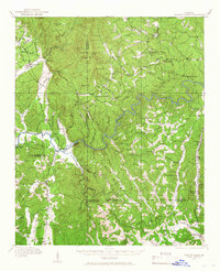
1914 Map of Talking Rock
USGS Topo · Published 1960About this map
Talking Rock and the surrounding river valleys of Gilmer, Pickens, and Gordon counties define this rural landscape during the early twentieth century. The topography is dominated by the winding course of the Coosawattee River and Talking Rock Creek, which carve through the foothills near Cohutta Mtn and Sevenmile Mountain. Settlement patterns follow the water and the Louisville and Nashville railroad, which services small communities like Whitestone and Talona along the eastern edge of the survey.
Find a feature on this map
88 named features on this map. Tap any name to fly to it.
Don’t see what you’re looking for? This feature index may not catch every label — zoom into the map to look around manually.
Map Details
Editions of this 1914 Talking Rock Map
2 editions found
Other maps of this area

1886 · Dalton
USGS Topo · 1:125,000

1888 · Ellijay
USGS Topo · 1:125,000

1890 · Suwanee
USGS Topo · 1:125,000

1890 · Cartersville
USGS Topo · 1:125,000

1891 · Cartersville
USGS Topo · 1:125,000

1892 · Ellijay
USGS Topo · 1:125,000

1892 · Dalton
USGS Topo · 1:125,000

1894 · Suwanee
USGS Topo · 1:125,000

1896 · Cartersville
USGS Topo · 1:125,000

1897 · Dalton
USGS Topo · 1:125,000