
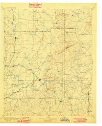
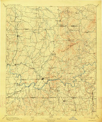
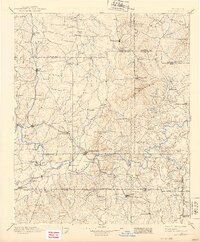
1896 Map of Cartersville
USGS Topo · Published 1896About this map
Etowah River serves as the central artery for this Georgia region, winding through a landscape defined by prominent ridges and early industrial infrastructure. The presence of numerous crossings, such as Wooden Bridge, Free Bridge, and Akeman Ferry, reveals the heavy reliance on river transport and local fords before the establishment of modern spans. The corridor is further shaped by the Western and Atlantic Railroad, which links key settlements like Adairsville and Kingston.
Find a feature on this map
113 named features on this map. Tap any name to fly to it.
Don’t see what you’re looking for? This feature index may not catch every label — zoom into the map to look around manually.
Map Details
Editions of this 1896 Cartersville Map
4 editions found
Other maps of this area

1886 · Dalton
USGS Topo · 1:125,000

1886 · Ringgold
USGS Topo · 1:125,000

1886 · Rome
USGS Topo · 1:125,000

1888 · Ellijay
USGS Topo · 1:125,000

1888 · Atlanta
USGS Topo · 1:125,000

1889 · Tallapoosa
USGS Topo · 1:125,000

1890 · Suwanee
USGS Topo · 1:125,000

1890 · Cartersville
USGS Topo · 1:125,000

1890 · Atlanta
USGS Topo · 1:125,000

1891 · Marietta
USGS Topo · 1:125,000