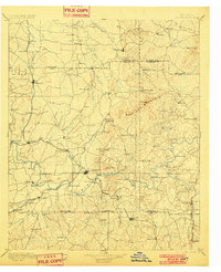
1896 Map of Cartersville
USGS Topo · Published 1901About this map
Cartersville serves as the focal point of this late 19th-century survey, situated at a critical junction of the Etowah River and the Western and Atlantic Railroad. The landscape is defined by the prominent ridge of Pine Log Mountain and a complex network of river crossings, including Webster Ferry, Galt Ferry, and the Wooden Bridge. This era shows a regional economy built upon water and rail, with industrial points like the Cement works near Linwood and numerous family-named operations such as Martins Mill and Cherokee Mills. Small settlements like Cassville, Adairsville, and Euharlee are well-established along the valley floors, connected by early thoroughfares like Warford X-Roads. The mapping of these river-bottom lands reveals the pre-industrial drainage patterns of Pettit Creek and Pumpkinvine Creek before later 20th-century water management projects altered the valley floors.
Find a feature on this map
115 named features on this map. Tap any name to fly to it.
Don’t see what you’re looking for? This feature index may not catch every label — zoom into the map to look around manually.
Map Details
Editions of this 1896 Cartersville Map
4 editions found

Other maps of this area

1886 · Dalton
USGS Topo · 1:125,000

1886 · Ringgold
USGS Topo · 1:125,000

1886 · Rome
USGS Topo · 1:125,000

1888 · Ellijay
USGS Topo · 1:125,000

1888 · Atlanta
USGS Topo · 1:125,000

1889 · Tallapoosa
USGS Topo · 1:125,000

1890 · Suwanee
USGS Topo · 1:125,000

1890 · Cartersville
USGS Topo · 1:125,000

1890 · Atlanta
USGS Topo · 1:125,000

1891 · Marietta
USGS Topo · 1:125,000