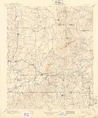
1896 Map of Cartersville
USGS Topo · Published 1939About this map
The Etowah River carves a central path through this late-19th-century landscape, acting as a focal point for the region's early transportation network. Dozens of river crossings are documented here, from the Akerman Ferry and Webster Ferry to the Wooden Bridge and Free Bridge. These crossings connected agricultural settlements like Lillypond, Sonora, and Fairmount to the industrial and trade hubs forming along the iron rails.
Find a feature on this map
113 named features on this map. Tap any name to fly to it.
Don’t see what you’re looking for? This feature index may not catch every label — zoom into the map to look around manually.
Map Details
Editions of this 1896 Cartersville Map
4 editions found

Other maps of this area

1886 · Dalton
USGS Topo · 1:125,000

1886 · Ringgold
USGS Topo · 1:125,000

1886 · Rome
USGS Topo · 1:125,000

1888 · Ellijay
USGS Topo · 1:125,000

1888 · Atlanta
USGS Topo · 1:125,000

1889 · Tallapoosa
USGS Topo · 1:125,000

1890 · Suwanee
USGS Topo · 1:125,000

1890 · Cartersville
USGS Topo · 1:125,000

1890 · Atlanta
USGS Topo · 1:125,000

1891 · Marietta
USGS Topo · 1:125,000