1889 Map of Tallapoosa
USGS Topo · Published 1889About this map
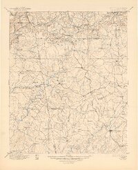
Industrial activity and rural settlement define this late 19th-century study of the Georgia-Alabama borderlands. The presence of the Tecumseh Furnace and nearby Holland Mine suggests a landscape shaped by iron and copper extraction, supported by the East Tennessee Virginia and Georgia Railroad. Along the winding courses of the Tallapoosa River and Little Tallapoosa River, numerous family-run operations like Young's Mill and Hooper's Mill reflect a grain and timber economy anchored to the waterways.
Find a feature on this map
141 named features on this map. Tap any name to fly to it.
Don’t see what you’re looking for? This feature index may not catch every label — zoom into the map to look around manually.
Map Details
Editions of this 1889 Tallapoosa Map
This is the sole edition of this map. No revisions or reprints were ever made.
Historical Maps of Carrollton Through Time
3 maps found