1892 Map of Tallapoosa
USGS Topo · Published 1892About this map
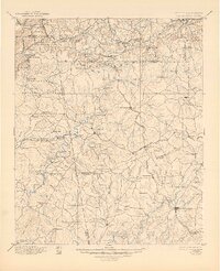
Industrial and agricultural development along the Georgia Alabama Boundary Line defines this 1892 edition, where the Tallapoosa River and its numerous tributaries power a dense network of timber and grist mills. The presence of Tecumseh Furnace and a Copper Mine near Eaves Bridge highlights the region's mineral wealth during this era of late-nineteenth-century expansion. The landscape is structured by the Dug Down Mountain range and the Pacific Railroad, which connects emerging commercial centers like Tallapoosa and Buchanan. Numerous family-named crossings, such as Rainwater Ford and Mc Bride Bridge, indicate the established rural transport routes that linked smaller settlements like Borden Springs and Esom Hill to the county seats at Carrollton and Buchanan before the modern highway system was developed.
Find a feature on this map
141 named features on this map. Tap any name to fly to it.
Don’t see what you’re looking for? This feature index may not catch every label — zoom into the map to look around manually.
Map Details
Editions of this 1892 Tallapoosa Map
This is the sole edition of this map. No revisions or reprints were ever made.
Historical Maps of Carrollton Through Time
3 maps found