1940s Maps of Calhoun, Georgia
Explore 3 historic maps of Calhoun from the 1940s. These maps offer a rare glimpse into what life looked like during the 1940s — showing old roads, neighborhoods, homes, and landmarks that have changed or disappeared over time.
Whether you're researching your family's past, planning a metal detecting trip, or studying how Calhoun's landscape evolved across the 1940s, these high-resolution maps are a powerful tool for exploring the history of this region.
- Focus on a specific era: All maps on this page are from the 1940s, giving you a focused view of this time period.
- See what’s changed: Compare century-old streets, trails, and buildings to today's modern landscape using overlays and satellite layers.
- Research with precision: Use these maps for genealogy, historical research, land use analysis, or educational projects.
- View, download, or print: Maps are fully viewable online in high resolution, and can be downloaded or printed for your own records.
Start exploring Calhoun's history through authentic maps from the 1940s. This is your window into the past.
Calhoun, GA maps
(3)- 1941 Map of Adairsville, 1964 Print
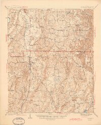
 1941 Adairsville1964 Print · USGSAdairsville and the rural borderlands of Gordon and Bartow counties are captured here just before the mid-century. Genealogists can trace family roots at Concord Cem, visit the Corra Harris Home, or locate old schoolhouses like Plainview Sch and Donaldson Sch.
 - 1944 Map of Adairsville
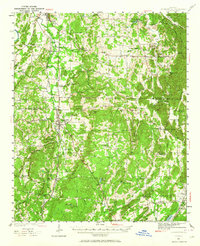
 1944 Adairsville1944 Print · USGSBartow and Gordon Counties are shown during the early years of the war, centered on the railroad crossing at Adairsville. Genealogists can locate family landmarks like the Corra Harris Home, Yarbroughs Mill, and Oak Grove Ch.2 unique versions available
 - 1949 Map of Calhoun, 1965 Print
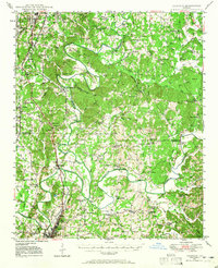 1949 Calhoun1965 Print · USGSNorthwest Georgia at mid-century reveals a landscape shaped by river confluences and early transportation routes like the Dixie Highway. Researchers can trace ancestral locations near Echota Village, Resaca Confederate Cemetery, and numerous country churches like Smyrna Church.
End of results
Showing maps 1-3 of 3
Top cities near Calhoun
- Rome historical maps
- Dalton historical maps
- Cartersville historical maps
- Adairsville historical maps
- Fairmount historical maps
- Resaca historical maps
See more
Top neighborhoods of Calhoun
Frequently asked questions
- What are the different types of historical maps available for Calhoun?
- What is the oldest map of Calhoun?
- Where can I purchase historical maps of Calhoun for my home or office?
- Where can I download high-res historical maps of Calhoun?
- Are there historical topographic maps available for Calhoun?
- Is there historical aerial imagery available for Calhoun?
- Where are historical maps of Calhoun sourced from?