1960s Maps of Hampton, Georgia
Explore 2 historic maps of Hampton from the 1960s. These maps offer a rare glimpse into what life looked like during the 1960s — showing old roads, neighborhoods, homes, and landmarks that have changed or disappeared over time.
Whether you're researching your family's past, planning a metal detecting trip, or studying how Hampton's landscape evolved across the 1960s, these high-resolution maps are a powerful tool for exploring the history of this region.
- Focus on a specific era: All maps on this page are from the 1960s, giving you a focused view of this time period.
- See what’s changed: Compare century-old streets, trails, and buildings to today's modern landscape using overlays and satellite layers.
- Research with precision: Use these maps for genealogy, historical research, land use analysis, or educational projects.
- View, download, or print: Maps are fully viewable online in high resolution, and can be downloaded or printed for your own records.
Start exploring Hampton's history through authentic maps from the 1960s. This is your window into the past.
Hampton, GA maps
(2)- 1965 Map of Hampton, 1967 Print
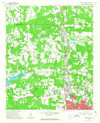
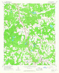 1965 Hampton1967 Print · USGSHampton and Lovejoy are captured during a period of transition in the mid-1960s, as traditional rail corridors met new regional infrastructure. Researchers can trace the Central of Georgia railroad, locate the Atlanta International Raceway, and find local landmarks like Shiloh Ch or Noah Ark.3 unique versions available
 - 1965 Map of Griffin North, 1967 Print
 1965 Griffin North1967 Print · USGSSpalding County's textile and agricultural roots are on full display during the mid-sixties as the northern outskirts of Griffin expand. Researchers can trace the industrial corridor of Highland Mills, the sprawling State Experimental Farms, and rural landmarks like West Sunny Side Ch.2 unique versions available
End of results
Showing maps 1-2 of 2
Top cities near Hampton
- Stockbridge historical maps
- McDonough historical maps
- Griffin historical maps
- Union City historical maps
- Forest Park historical maps
- Fayetteville historical maps
See more
Top neighborhoods of Hampton
- Fortson historical maps
- West Hampton historical maps
- Clover Ranch Mobile Home Park historical maps
- Woodlawn historical maps
- Main Street Commons historical maps
Frequently asked questions
- What are the different types of historical maps available for Hampton?
- What is the oldest map of Hampton?
- Where can I purchase historical maps of Hampton for my home or office?
- Where can I download high-res historical maps of Hampton?
- Are there historical topographic maps available for Hampton?
- Is there historical aerial imagery available for Hampton?
- Where are historical maps of Hampton sourced from?