1960s Maps of McDonough, Georgia
Explore 2 historic maps of McDonough from the 1960s. These maps offer a rare glimpse into what life looked like during the 1960s — showing old roads, neighborhoods, homes, and landmarks that have changed or disappeared over time.
Whether you're researching your family's past, planning a metal detecting trip, or studying how McDonough's landscape evolved across the 1960s, these high-resolution maps are a powerful tool for exploring the history of this region.
- Focus on a specific era: All maps on this page are from the 1960s, giving you a focused view of this time period.
- See what’s changed: Compare century-old streets, trails, and buildings to today's modern landscape using overlays and satellite layers.
- Research with precision: Use these maps for genealogy, historical research, land use analysis, or educational projects.
- View, download, or print: Maps are fully viewable online in high resolution, and can be downloaded or printed for your own records.
Start exploring McDonough's history through authentic maps from the 1960s. This is your window into the past.
McDonough, GA maps
(2)- 1964 Map of Mc Donough, 1965 Print
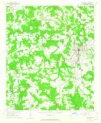 1964 Mc Donough1965 Print · USGSHenry County in the mid-1960s was a landscape of deep-rooted rural communities tied together by the Southern railroad and country churches. Genealogists and local historians can trace family locations through markers like Cleveland Cem, Turner Church, and the Shingle Roof Campground.4 unique versions available
 - 1964 Map of Ola, 1965 Print
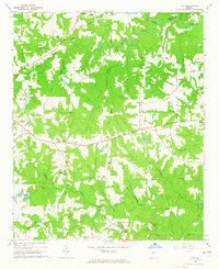 1964 Ola1965 Print · USGSHenry County remains a pastoral landscape of family farms and creek-side settlements in the mid-1960s. Genealogists can trace family roots through numerous sites like Old Mt Bethel Cem, Humphrey Cem, and the community hub at Ola.3 unique versions available
End of results
Showing maps 1-2 of 2
Top cities near McDonough
- Atlanta historical maps
- Stonecrest historical maps
- Stockbridge historical maps
- Griffin historical maps
- Forest Park historical maps
- Conyers historical maps
See more
Top neighborhoods of McDonough
Frequently asked questions
- What are the different types of historical maps available for McDonough?
- What is the oldest map of McDonough?
- Where can I purchase historical maps of McDonough for my home or office?
- Where can I download high-res historical maps of McDonough?
- Are there historical topographic maps available for McDonough?
- Is there historical aerial imagery available for McDonough?
- Where are historical maps of McDonough sourced from?