1970s Maps of Barnesville, Georgia
Explore 3 historic maps of Barnesville from the 1970s. These maps offer a rare glimpse into what life looked like during the 1970s — showing old roads, neighborhoods, homes, and landmarks that have changed or disappeared over time.
Whether you're researching your family's past, planning a metal detecting trip, or studying how Barnesville's landscape evolved across the 1970s, these high-resolution maps are a powerful tool for exploring the history of this region.
- Focus on a specific era: All maps on this page are from the 1970s, giving you a focused view of this time period.
- See what’s changed: Compare century-old streets, trails, and buildings to today's modern landscape using overlays and satellite layers.
- Research with precision: Use these maps for genealogy, historical research, land use analysis, or educational projects.
- View, download, or print: Maps are fully viewable online in high resolution, and can be downloaded or printed for your own records.
Start exploring Barnesville's history through authentic maps from the 1970s. This is your window into the past.
Barnesville, GA maps
(3)- 1973 Map of Johnstonville, 1976 Print
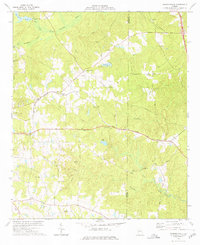 1973 Johnstonville1976 Print · USGSLamar and Monroe counties show their rural character in the early 1970s, as the railway still connected small local junctions. Genealogists can trace family footprints across dozens of sites like Goggins, Sappington Cem, and Bethany Ch.
 - 1973 Map of Barnesville, 1976 Print
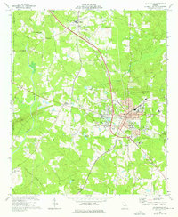 1973 Barnesville1976 Print · USGSLamar and Pike counties are captured in the mid-1970s, showcasing the intersection of the Central of Georgia railroad and the growth of Barnesville. Trace historical landmarks such as Gordon Jr College, the Confederate Cem, and Woodfin Mill.
 - 1979 Map of Griffin, 1980 Print
 1979 Griffin1980 Print · USGSWest-central Georgia at the close of the seventies reveals a landscape of historic rail towns and growing suburbs between the major river systems. Trace the rail lines and early road networks connecting Griffin, Peachtree City, and Newnan, or locate smaller settlements like Senoia and Experiment.3 unique versions available
End of results
Showing maps 1-3 of 3
Top cities near Barnesville
- Griffin historical maps
- Thomaston historical maps
- Jackson historical maps
- Forsyth historical maps
- Hannahs Mill historical maps
- Experiment historical maps
See more
Frequently asked questions
- What are the different types of historical maps available for Barnesville?
- What is the oldest map of Barnesville?
- Where can I purchase historical maps of Barnesville for my home or office?
- Where can I download high-res historical maps of Barnesville?
- Are there historical topographic maps available for Barnesville?
- Is there historical aerial imagery available for Barnesville?
- Where are historical maps of Barnesville sourced from?