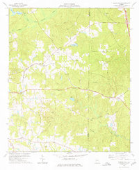
1973 Map of Johnstonville
USGS Topo · Published 1976About this map
Johnstonville and its surrounding rural landscape in Lamar County and Monroe County are defined by a network of small creeks and community landmarks in the early 1970s. The Central of Georgia railroad cuts through the center of the sheet, connecting the small settlements of Goggins, Phinazee, and Collier. This area is particularly dense with historic congregational sites and family burial grounds, such as Bethany Ch and the Sappington Cem, reflecting the deep-rooted local heritage of middle Georgia. The terrain transitions from the Towaliga River in the north to the headwaters of Tobesofkee Creek in the south, punctuated by local water features like Childs Pond and Potts Pond. The map serves as a detailed record of land use before significant modern development, showing a countryside of winding roads like Johnstonville Road and scattered farmsteads.
Find a feature on this map
46 named features on this map. Tap any name to fly to it.
Don’t see what you’re looking for? This feature index may not catch every label — zoom into the map to look around manually.
Map Details
Editions of this 1973 Johnstonville Map
This is the sole edition of this map. No revisions or reprints were ever made.
Other maps of this area

1951 · Yatesville
USGS Topo · 1:62,500

1951 · Forsyth
USGS Topo · 1:62,500

1951 · Barnesville
USGS Topo · 1:62,500

1953 · Atlanta
USGS Topo · 1:250,000

1953 · Athens
USGS Topo · 1:250,000

1955 · Phenix City
USGS Topo · 1:250,000

1956 · Bolingbroke
USGS Topo · 1:62,500

1957 · Phenix City
USGS Topo · 1:250,000

1957 · Macon
USGS Topo · 1:250,000

1957 · Atlanta
USGS Topo · 1:250,000