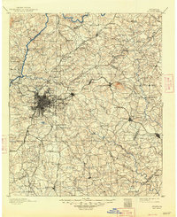
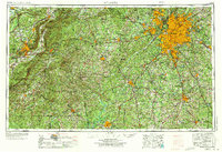
1957 Map of Atlanta
USGS Topo · Published 1957About this map
The metropolitan expansion of Atlanta dominates the eastern half of this mid-century survey, showing the city's early suburban footprint stretching toward Marietta, Decatur, and College Park. Significant federal footprints are visible at Fort McPherson and the sprawling Fort McClellan Military Reservation near Anniston. The landscape is defined by the Chattahoochee River corridor and prominent terrain features such as Stone Mountain and the high peaks of the Talladega National Forest, including Cheaha Mountain. Transport networks of the era are clearly delineated, featuring the Southern Railway and Seaboard Air Line Railroad alongside established thoroughfares like U.S. Highway 78. This edition captures the region as major reservoirs like Lake Sidney Lanier and Jackson Lake were becoming central to the geography of North Georgia and Eastern Alabama.
Find a feature on this map
75 named features on this map. Tap any name to fly to it.
Don’t see what you’re looking for? This feature index may not catch every label — zoom into the map to look around manually.
Map Details
Editions of this 1957 Atlanta Map
This is the sole edition of this map. No revisions or reprints were ever made.
Historical Maps of Atlanta Through Time
8 maps found