1970s Maps of East Dublin, Georgia
Explore 2 historic maps of East Dublin from the 1970s. These maps offer a rare glimpse into what life looked like during the 1970s — showing old roads, neighborhoods, homes, and landmarks that have changed or disappeared over time.
Whether you're researching your family's past, planning a metal detecting trip, or studying how East Dublin's landscape evolved across the 1970s, these high-resolution maps are a powerful tool for exploring the history of this region.
- Focus on a specific era: All maps on this page are from the 1970s, giving you a focused view of this time period.
- See what’s changed: Compare century-old streets, trails, and buildings to today's modern landscape using overlays and satellite layers.
- Research with precision: Use these maps for genealogy, historical research, land use analysis, or educational projects.
- View, download, or print: Maps are fully viewable online in high resolution, and can be downloaded or printed for your own records.
Start exploring East Dublin's history through authentic maps from the 1970s. This is your window into the past.
East Dublin, GA maps
(2)- 1974 Map of East Dublin, 1976 Print
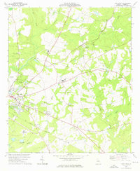 1974 East Dublin1976 Print · USGSEast Dublin and its surrounding Laurens County hamlets are captured in the mid-1970s, showcasing a landscape of active rail lines and rural churches. Researchers can trace family sites like Zion Hill Ch and Josey Academy or locate the East Dublin Drive-in Theater.2 unique versions available
 - 1974 Map of Dublin, 1977 Print
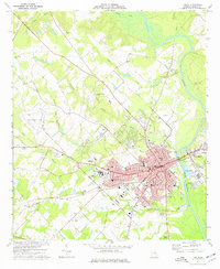 1974 Dublin1977 Print · USGSDublin and its riverfront neighbor were thriving Laurens County hubs during the mid-seventies, split by the Oconee River. Local historians can trace the development of the Veterans Hospital, several rural churches like Rice Hill Ch, and the path of the Central of Georgia railroad.2 unique versions available
End of results
Showing maps 1-2 of 2
Top cities near East Dublin
- Dublin historical maps
- Wrightsville historical maps
- Dexter historical maps
- Dudley historical maps
- Cadwell historical maps
- Rentz historical maps
Frequently asked questions
- What are the different types of historical maps available for East Dublin?
- What is the oldest map of East Dublin?
- Where can I purchase historical maps of East Dublin for my home or office?
- Where can I download high-res historical maps of East Dublin?
- Are there historical topographic maps available for East Dublin?
- Is there historical aerial imagery available for East Dublin?
- Where are historical maps of East Dublin sourced from?