1970s Maps of Smithville, Georgia
Explore 2 historic maps of Smithville from the 1970s. These maps offer a rare glimpse into what life looked like during the 1970s — showing old roads, neighborhoods, homes, and landmarks that have changed or disappeared over time.
Whether you're researching your family's past, planning a metal detecting trip, or studying how Smithville's landscape evolved across the 1970s, these high-resolution maps are a powerful tool for exploring the history of this region.
- Focus on a specific era: All maps on this page are from the 1970s, giving you a focused view of this time period.
- See what’s changed: Compare century-old streets, trails, and buildings to today's modern landscape using overlays and satellite layers.
- Research with precision: Use these maps for genealogy, historical research, land use analysis, or educational projects.
- View, download, or print: Maps are fully viewable online in high resolution, and can be downloaded or printed for your own records.
Start exploring Smithville's history through authentic maps from the 1970s. This is your window into the past.
Smithville, GA maps
(2)- 1973 Map of Smithville West, 1976 Print
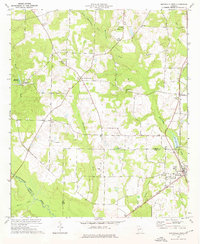 1973 Smithville West1976 Print · USGSThe agricultural plains of Sumter and Lee Counties are captured here in the early seventies, centered on the rail-side community of Smithville. Researchers can find numerous rural landmarks, from the Smithville Academy and Green Grove Sch to historic congregations at Hebron Ch and St Pauls Ch.
 - 1973 Map of Smithville East, 1976 Print
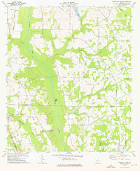 1973 Smithville East1976 Print · USGSSumter and Lee Counties in the early seventies reveal a landscape of deep creek bottoms and railroad corridors. Genealogists and historians can trace family roots through the Anthony Cem, Deldrich Cem, and Mt Pleasant Ch.2 unique versions available
End of results
Showing maps 1-2 of 2
Top cities near Smithville
- Americus historical maps
- Dawson historical maps
- Leesburg historical maps
- Plains historical maps
- Bronwood historical maps
- Leslie historical maps
See more
Frequently asked questions
- What are the different types of historical maps available for Smithville?
- What is the oldest map of Smithville?
- Where can I purchase historical maps of Smithville for my home or office?
- Where can I download high-res historical maps of Smithville?
- Are there historical topographic maps available for Smithville?
- Is there historical aerial imagery available for Smithville?
- Where are historical maps of Smithville sourced from?