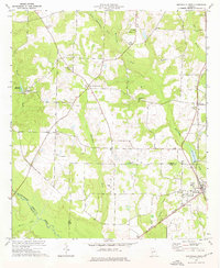
1973 Map of Smithville West
USGS Topo · Published 1976About this map
Smithville serves as the focal point of this southwestern Georgia landscape during the early 1970s, situated at the confluence of several rural transport corridors. The Central of Georgia railroad cuts through the eastern portion of the sheet, supporting the small agricultural communities of Sumter and Smithville. This area is characterized by a high density of rural institutions, including the Smithville Academy and Green Grove Sch, alongside a remarkable concentration of country churches such as Jerusalem Grove Ch, Zion Hope Ch, and Mitchell Grove Ch.
Find a feature on this map
33 named features on this map. Tap any name to fly to it.
Don’t see what you’re looking for? This feature index may not catch every label — zoom into the map to look around manually.
Map Details
Editions of this 1973 Smithville West Map
This is the sole edition of this map. No revisions or reprints were ever made.
Other maps of this area

1953 · Dothan
USGS Topo · 1:250,000

1954 · Dothan
USGS Topo · 1:250,000

1955 · Dothan
USGS Topo · 1:250,000

1955 · Phenix City
USGS Topo · 1:250,000

1956 · Leslie
USGS Topo · 1:62,500

1957 · Phenix City
USGS Topo · 1:250,000

1958 · Phenix City
USGS Topo · 1:250,000

1973 · Dawson
USGS Topo · 1:24,000
1973 · Americus
USGS Topo · 1:24,000
1973 · Plains
USGS Topo · 1:24,000