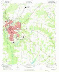
1973 Map of Americus
USGS Topo · Published 1975About this map
Americus serves as a major regional hub in Sumter County during the mid-1970s, characterized by its dense grid of streets like Lamar St and Forsyth St and a convergence of railroad lines including the Central of Georgia and Seaboard Coast Line. This era shows the community supporting significant educational and social institutions, from Georgia Southwestern College to the South Georgia Home For the Aged.
Find a feature on this map
90 named features on this map. Tap any name to fly to it.
Don’t see what you’re looking for? This feature index may not catch every label — zoom into the map to look around manually.
Map Details
Editions of this 1973 Americus Map
2 editions found
Other maps of this area

1953 · Dothan
USGS Topo · 1:250,000

1954 · Dothan
USGS Topo · 1:250,000

1955 · Dothan
USGS Topo · 1:250,000

1955 · Phenix City
USGS Topo · 1:250,000

1956 · Leslie
USGS Topo · 1:62,500

1957 · Phenix City
USGS Topo · 1:250,000

1958 · Phenix City
USGS Topo · 1:250,000

1972 · Ellaville South
USGS Topo · 1:24,000
1972 · Methvins
USGS Topo · 1:24,000
1972 · Andersonville
USGS Topo · 1:24,000