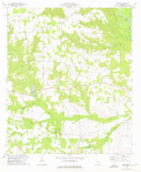
1972 Map of Methvins
USGS Topo · Published 1975About this map
The Flint River forms the northeastern boundary of this agricultural landscape in Sumter County, where the terrain is defined by a dense network of tributaries including Lime Creek and Hurricane Branch. This 1970s survey captures the rural settlement patterns around Methvins and Lamar, characterized by dispersed family farms and community anchors. Local social life is centered around numerous country churches such as New Corinth Ch and Mt Hope Ch, often accompanied by family or community burial grounds like Friendship Cem and Pleasant Grove Cem. The presence of Browns Millpond along the course of Little Lime Creek suggests a history of local water management for mill operations, while the surrounding wetlands and creek bottoms like Po Hog Branch illustrate the intricate drainage patterns that have long influenced Georgia's coastal plain farming.
Find a feature on this map
20 named features on this map. Tap any name to fly to it.
Don’t see what you’re looking for? This feature index may not catch every label — zoom into the map to look around manually.
Map Details
Editions of this 1972 Methvins Map
2 editions found
Other maps of this area

1953 · Dothan
USGS Topo · 1:250,000

1953 · Waycross
USGS Topo · 1:250,000

1954 · Dothan
USGS Topo · 1:250,000

1955 · Dothan
USGS Topo · 1:250,000

1955 · Phenix City
USGS Topo · 1:250,000

1956 · Leslie
USGS Topo · 1:62,500

1957 · Phenix City
USGS Topo · 1:250,000

1957 · Macon
USGS Topo · 1:250,000

1958 · Macon
USGS Topo · 1:250,000

1958 · Phenix City
USGS Topo · 1:250,000