1970s Maps of Ludowici, Georgia
Explore 3 historic maps of Ludowici from the 1970s. These maps offer a rare glimpse into what life looked like during the 1970s — showing old roads, neighborhoods, homes, and landmarks that have changed or disappeared over time.
Whether you're researching your family's past, planning a metal detecting trip, or studying how Ludowici's landscape evolved across the 1970s, these high-resolution maps are a powerful tool for exploring the history of this region.
- Focus on a specific era: All maps on this page are from the 1970s, giving you a focused view of this time period.
- See what’s changed: Compare century-old streets, trails, and buildings to today's modern landscape using overlays and satellite layers.
- Research with precision: Use these maps for genealogy, historical research, land use analysis, or educational projects.
- View, download, or print: Maps are fully viewable online in high resolution, and can be downloaded or printed for your own records.
Start exploring Ludowici's history through authentic maps from the 1970s. This is your window into the past.
Ludowici, GA maps
(3)- 1970 Map of Doctortown, 1973 Print
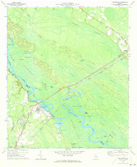 1970 Doctortown1973 Print · USGSThe Altamaha River bottomlands in the early seventies reveal a world of interconnected swamps and river-dependent industry. Genealogists and historians can locate Doctortown and Ludowici, or trace landmarks like the Elem Ch and the Drive-in Theater.3 unique versions available
 - 1978 Map of Ludowici
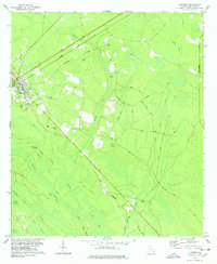 1978 Ludowici1978 Print · USGSLong County, Georgia, is documented here in the late seventies as the community of Ludowici centers a landscape of rail lines and coastal swamps. Genealogists and local historians can locate several family burial sites like Baggs Cem and Sharp Cem or trace the path of the Seaboard Coast Line.
 - 1978 Map of Brunswick
 1978 Brunswick1978 Print · USGSThe Georgia coast and its barrier islands are captured in the late 1970s, as I-95 and the rail lines shaped the growth of coastal towns. Genealogists and historians can trace family locations across the islands or locate sites near Fort Stewart, Darien, and Ludowici.2 unique versions available
End of results
Showing maps 1-3 of 3
Top cities near Ludowici
- Hinesville historical maps
- Jesup historical maps
- Glennville historical maps
- Fort Stewart historical maps
- Walthourville historical maps
- Allenhurst historical maps
See more
Frequently asked questions
- What are the different types of historical maps available for Ludowici?
- What is the oldest map of Ludowici?
- Where can I purchase historical maps of Ludowici for my home or office?
- Where can I download high-res historical maps of Ludowici?
- Are there historical topographic maps available for Ludowici?
- Is there historical aerial imagery available for Ludowici?
- Where are historical maps of Ludowici sourced from?