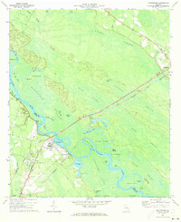
1970 Map of Doctortown
USGS Topo · Published 1973About this map
The Altamaha River defines the landscape of this coastal plain survey, serving as the boundary between Long and Wayne Counties. The river's winding path is flanked by expansive wetland systems, including Patterson Swamp and Back Swamp, characterized by numerous oxbow lakes and sloughs such as Dunns Lake and Floyds Slough. The industrial presence of Doctortown is prominent near the river crossing, marked by several Industrial Waste Ponds and a Water Tank.
Find a feature on this map
63 named features on this map. Tap any name to fly to it.
Don’t see what you’re looking for? This feature index may not catch every label — zoom into the map to look around manually.
Map Details
Editions of this 1970 Doctortown Map
Other maps of this area

1918 · Jesup
USGS Topo · 1:62,500

1918 · Hinesville
USGS Topo · 1:62,500

1920 · Glennville
USGS Topo · 1:62,500

1943 · Ludowici
USGS Topo · 1:62,500

1943 · Jesup
USGS Topo · 1:62,500

1944 · Glennville
USGS Topo · 1:62,500

1944 · Hinesville
USGS Topo · 1:62,500

1946 · Brunswick
USGS Topo · 1:250,000

1948 · Brunswick
USGS Topo · 1:250,000

1950 · Glennville
USGS Topo · 1:62,500