1943 Map of Jesup
USGS Topo · Published 1943About this map
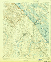
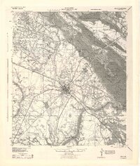
Jesup serves as a major rail hub in this 1943 War Department survey, where the Southern and Atlantic Coast Line railroads intersect. The surrounding landscape of Wayne County is defined by its relationship with the Altamaha River, which forms a complex network of wetlands and islands including Nigger Island and Shoe Island. Evidence of the era's local infrastructure is visible at the County Farm near Doctortown and the numerous small rural schools like Empire Sch and Flint Branch Sch that served scattered agricultural communities.
Find a feature on this map
65 named features on this map. Tap any name to fly to it.
Don’t see what you’re looking for? This feature index may not catch every label — zoom into the map to look around manually.
Map Details
Editions of this 1943 Jesup Map
This is the sole edition of this map. No revisions or reprints were ever made.