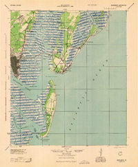
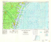
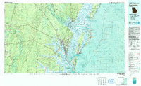
1946 Map of Brunswick
USGS Topo · Published 1948About this map
The Camp Stewart Military Reservation dominates the northwestern interior of this coastal Georgia region, illustrating the significant military footprint established during the mid-1940s. Moving toward the shoreline, the landscape transforms into a complex network of barrier islands and tidal sounds, including Sapelo Island, St Simon Island, and Jekyll Island. These coastal features are separated from the mainland by an intricate system of waterways like the South Newport River and Buttermilk Sound.
Find a feature on this map
99 named features on this map. Tap any name to fly to it.
Don’t see what you’re looking for? This feature index may not catch every label — zoom into the map to look around manually.
Map Details
Editions of this 1946 Brunswick Map
This is the sole edition of this map. No revisions or reprints were ever made.
Historical Maps of Savannah Through Time
7 maps found