1930s Maps of Porter Springs, Georgia
Explore 2 historic maps of Porter Springs from the 1930s. These maps offer a rare glimpse into what life looked like during the 1930s — showing old roads, neighborhoods, homes, and landmarks that have changed or disappeared over time.
Whether you're researching your family's past, planning a metal detecting trip, or studying how Porter Springs's landscape evolved across the 1930s, these high-resolution maps are a powerful tool for exploring the history of this region.
- Focus on a specific era: All maps on this page are from the 1930s, giving you a focused view of this time period.
- See what’s changed: Compare century-old streets, trails, and buildings to today's modern landscape using overlays and satellite layers.
- Research with precision: Use these maps for genealogy, historical research, land use analysis, or educational projects.
- View, download, or print: Maps are fully viewable online in high resolution, and can be downloaded or printed for your own records.
Start exploring Porter Springs's history through authentic maps from the 1930s. This is your window into the past.
Porter Springs, GA maps
(2)- 1935 Map of Neels Gap
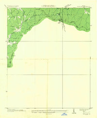 1935 Neels Gap1935 Print · USGSThe high peaks of the Blue Ridge come into focus during the mid-1930s as early park infrastructure and mountain trails are established. Trace the original path of the Appalachian Trail past Blood Mtn, Zion Ch, and the heights of Neels Gap.
 - 1938 Map of Neels Gap
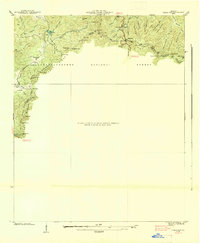 1938 Neels Gap1938 Print · USGSThe high ridges of Lumpkin and Union counties are shown in the late 1930s, just as the region’s modern parks were taking shape. Researchers can trace the early Appalachian Trail, the grounds of Vogel State Park, and the community at Zion Church.
End of results
Showing maps 1-2 of 2
Top cities near Porter Springs
- Dahlonega historical maps
- Cleveland historical maps
- Dawsonville historical maps
- Clermont historical maps
- Helen historical maps
Frequently asked questions
- What are the different types of historical maps available for Porter Springs?
- What is the oldest map of Porter Springs?
- Where can I purchase historical maps of Porter Springs for my home or office?
- Where can I download high-res historical maps of Porter Springs?
- Are there historical topographic maps available for Porter Springs?
- Is there historical aerial imagery available for Porter Springs?
- Where are historical maps of Porter Springs sourced from?