1970s Maps of Madison County, Georgia
Explore 7 historic maps of Madison County from the 1970s. These maps offer a rare glimpse into what life looked like during the 1970s — showing old roads, neighborhoods, homes, and landmarks that have changed or disappeared over time.
Whether you're researching your family's past, planning a metal detecting trip, or studying how Madison County's landscape evolved across the 1970s, these high-resolution maps are a powerful tool for exploring the history of this region.
- Focus on a specific era: All maps on this page are from the 1970s, giving you a focused view of this time period.
- See what’s changed: Compare century-old streets, trails, and buildings to today's modern landscape using overlays and satellite layers.
- Research with precision: Use these maps for genealogy, historical research, land use analysis, or educational projects.
- View, download, or print: Maps are fully viewable online in high resolution, and can be downloaded or printed for your own records.
Start exploring Madison County's history through authentic maps from the 1970s. This is your window into the past.
Madison County, GA maps
(7)- 1972 Map of Danielsville South, 1974 Print
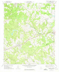 1972 Danielsville South1974 Print · USGSMadison County's agricultural and transit corridors are captured here during the 1970s. Genealogists and historians can trace family locations through numerous rural landmarks like Collier Ch, the Hitchcock Cem, and the path of the Seaboard Coast Line railroad.
 - 1972 Map of Bowman, 1974 Print
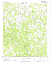 1972 Bowman1974 Print · USGSElbert and Madison counties meet along the Broad River during the early seventies, a landscape of rural communities and railroad stops. Genealogists can trace family footprints at Vanna, Harrison, and numerous local sites like Oak Grove Ch and Holly Springs Ch.
 - 1972 Map of Danielsville North, 1974 Print
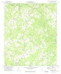 1972 Danielsville North1974 Print · USGSMadison County's rural character is preserved here in the early seventies, showing a landscape of river-fed valleys and quiet crossroads. Genealogists can trace family ties at Bethel Cem, Jones Chapel, and the historic county seat of Danielsville.2 unique versions available
 - 1972 Map of Carlton, 1974 Print
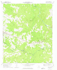 1972 Carlton1974 Print · USGSMadison and Elbert counties meet along the river in the early 1970s, as rural life centered on the SEABOARD COAST LINE rail corridor. Genealogists can trace family landmarks like Thankful Grove Ch, Old Fork Cem, and the historic WATSON MILL.
 - 1973 Map of Elberton West, 1975 Print
 1973 Elberton West1975 Print · USGSElbert County's granite industry and river-side settlements are shown here as they appeared in the early seventies. You can trace the SEABOARD COAST LINE through rural Oglesby and Ethridge or locate family landmarks like Antioch Ch and Central Sch.2 unique versions available
 - 1979 Map of Abbeville, 1980 Print
 1979 Abbeville1980 Print · USGSThe South Carolina and Georgia borderlands are captured here during a period of significant hydroelectric development and regional growth. Researchers can trace the rail-and-river economy through the Seaboard Coast Line and landmarks like Hartwell Dam or the Silk Mills.2 unique versions available
 - 1979 Map of Commerce, 1980 Print
 1979 Commerce1980 Print · USGSThe Georgia and South Carolina Piedmont reached a period of significant regional growth in the late seventies. Genealogists and historians can trace family roots through locations like Blackberry Church, Old Pioneer Cem, and the Gillsville Sch.2 unique versions available
End of results
Showing maps 1-7 of 7
Top cities of Madison County
- Comer historical maps
- Colbert historical maps
- Danielsville historical maps
- Ila historical maps
- Carlton historical maps
- Hull historical maps
Frequently asked questions
- What are the different types of historical maps available for Madison County?
- What is the oldest map of Madison County?
- Where can I purchase historical maps of Madison County for my home or office?
- Where can I download high-res historical maps of Madison County?
- Are there historical topographic maps available for Madison County?
- Is there historical aerial imagery available for Madison County?
- Where are historical maps of Madison County sourced from?