1970s Maps of Ansley Mill, Georgia
Explore 2 historic maps of Ansley Mill from the 1970s. These maps offer a rare glimpse into what life looked like during the 1970s — showing old roads, neighborhoods, homes, and landmarks that have changed or disappeared over time.
Whether you're researching your family's past, planning a metal detecting trip, or studying how Ansley Mill's landscape evolved across the 1970s, these high-resolution maps are a powerful tool for exploring the history of this region.
- Focus on a specific era: All maps on this page are from the 1970s, giving you a focused view of this time period.
- See what’s changed: Compare century-old streets, trails, and buildings to today's modern landscape using overlays and satellite layers.
- Research with precision: Use these maps for genealogy, historical research, land use analysis, or educational projects.
- View, download, or print: Maps are fully viewable online in high resolution, and can be downloaded or printed for your own records.
Start exploring Ansley Mill's history through authentic maps from the 1970s. This is your window into the past.
Ansley Mill, GA maps
(2)- 1972 Map of Winfield, 1973 Print
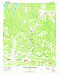 1972 Winfield1973 Print · USGSEastern Georgia's rural borderlands are captured in the early 1970s, showcasing the small communities of McDuffie and Columbia counties. Local historians can trace established homesteads and spiritual hubs like Ansley Mill, Jones Chapel, and the settlement of Winfield.
 - 1979 Map of Winfield, 1985 Print
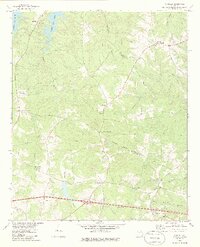 1979 Winfield1985 Print · USGSThe rural borders of McDuffie and Columbia counties are captured here in the late seventies, a landscape defined by creeks and country crossroads. Researchers can trace the location of community anchors like Ansley Mill, White Oak Grove Ch, and the waters of Clarks Hill Lake.
End of results
Showing maps 1-2 of 2
Top cities near Ansley Mill
- Augusta historical maps
- Grovetown historical maps
- Thomson historical maps
- Harlem historical maps
- Appling historical maps
- Dearing historical maps
See more
Frequently asked questions
- What are the different types of historical maps available for Ansley Mill?
- What is the oldest map of Ansley Mill?
- Where can I purchase historical maps of Ansley Mill for my home or office?
- Where can I download high-res historical maps of Ansley Mill?
- Are there historical topographic maps available for Ansley Mill?
- Is there historical aerial imagery available for Ansley Mill?
- Where are historical maps of Ansley Mill sourced from?